Category:Mission
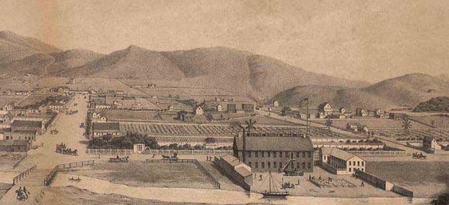
Artist's rendering of the view west on 16th Street (then Center Street) towards the woolen mills, farms, and waterworks owned by John Center between approximately Harrison and Mission, 16th and 15th today.
Photo: Private Collection, San Francisco, CA
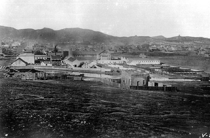
Looking west in the 1860s from approximately 16th and Alabama Streets, Mt. Olympus and Buena Vista Park peak visible in both pictures.
Photo: Private Collection, San Francisco, CA
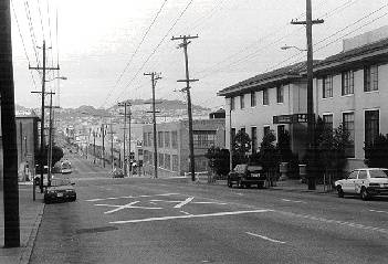
Looking west from 16th and Alabama in 1994; Mt. Olympus is the bump on the skyline, left-center.
Photo: Chris Carlsson
Text partially excerpted from 'The District Handbook: A CORO Foundation Guide' (1979) with additions by Chris Carlsson (2015)
The Mission takes its name from the first European settlement in what is now the city, one of thirteen Franciscan missions established under Fr. Junipero Serra. The original Mission is intact (with a mural painted close to its founding recently discovered), adjacent to its old cemetery on Dolores Street just off 16th Street. Dolores Street is part of the old El Camino Real (still the name for the major suburban six-lane strip running through the peninsula's towns) and there are one or two of the old curving bells which were placed along the original route in the early 1900s as a promotional campaign. The Mission was established in 1776 near the shores of the original tidal inlet that was fed by Mission Creek, that still runs underground in culverts on 18th from its source on the eastern slopes of Twin Peaks near Corbett and Clayton. The Mexican land grants to the De Haro family and the Bernal family divided the territory between today's Potrero Hill and Bernal Heights. Neither family prevailed in decades-long legal procedures from the 1850s-80s trying to retain their property rights against thousands of squatters.
In its earliest days, the Mission District was a mixed neighborhood of Eastern European, Irish, Swedish, and German immigrants. The neighborhood transformed, however, after the 1906 earthquake and fire. The Mission District was one of the few neighborhoods in the city that was not burned to the ground in the devastating fires that ravaged the city after the quake. Residents of burned-out areas, especially the South of Market area, moved to the Mission and pushed out the middle class families that had occupied the neighborhood, making it into a low-income working class neighborhood and the most heavily Irish area of San Francisco. This migration of Irish families extended to Noe Valley, Eureka Valley, Potrero Hill, Bernal Heights and Glen Park. Many Italian immigrants also moved into the Mission after 1906.
In the late 1950s, the Latino community that had been centered on the Guadalupe Church in North Beach began moving over to the Mission, making St. Peter's church on lower 24th Street a majority Spanish-speaking parish by the late 1960s. Fed by waves of immigrants, some fleeing from the Central American civil wars that burned hot during the 1970s-80s, the neighborhood took on its Latino identity more fully. But after the gentrification that began in the mid-1990s, property values have soared along with evictions and displacements, the Mission is in transition again. New multimillion dollar condominiums have replaced gas stations and auto repair shops. Punk rockers and the lesbian community that moved in during the late 1970s and early 1980s have given way to a plethora of upscale restaurants and bars, clothing boutiques, and galleries. The neighborhood is home to extreme wealth and poverty, and still provides the culturally rich and dynamic energy that has attracted so many. But there is a foreboding sense that what has made the Mission special is being lost as the years go by.
Pages in category "Mission"
The following 200 pages are in this category, out of 363 total.
(previous page) (next page)1
A
- A Brief History of Cesar Chavez/Army Street
- A Brief History of the Dearborn Garden
- A City for Idiots
- A San Francisco Matron
- A Visit to 1816 San Francisco
- AFFORDABLE HOUSING
- AIDS Epidemic and Day of the Dead: The Overlooked Connection
- All Co-op Meetings of the People’s Food System
- Alto al Fuego en la Misión
- American Can Company Strike 1938
- An Eyewitness Recounts the Quake of 1906
- APOCAPOLITICS IN PRACTICE: THE END OF THE WORLD'S FAIR
- Architectural Mission
- Architectural Mission Points
- Armory
- Artist! Mike Mosher
- Artists' Television Access
- At Woodward's Gardens by Robert Frost
- Attack on City College SF
B
- Backing Into a History Commons: A History of Shaping San Francisco
- Balmy Alley: a Modernist Approach
- Bancroft's History Factory
- BART Changes the Mission, April 1970
- BART's Plans for the Mission: Tacos, Towers, and Miniature Vehicles
- Baseball 1926-29
- Baseball Teens-20s
- Basta Ya Mastheads
- Bay Area Collectives in the Early 1980s
- Bernal Cut
- Black Lives Matter—June 2020
- Blacksmithery on 23rd and Treat
- Borden Dairy
- Building Boom on Known Quake Hazards
- Building San Francisco's BART tunnels
C
- Carol Seajay, Old Wives Tales and the Feminist Bookstore Network
- Cattle Raids of Creely
- CELLspace
- CELLspace: 1996-2012
- Cement Art
- Cement Factory to Condos at 17th and Harrison
- Central American Solidarity and Art
- Centro de Cambio
- Centro de Salud
- Centro Social Obrero
- Clarion Alley and Post-modernism
- Clarion Alley Gallery
- Cogswell Polytechnical College
- Coming Out into the 1970s
- Communalism in San Francisco
- Community Cultural Centers of San Francisco
- Community Murals
- Coronado Playground, 21st and Folsom
- Counting Souls in San Francisco for the U.S. Census During Covid-19
- Covid Days on 26th and Folsom
- COVID-19 Diaries
- Covid-19: Essential, Sick, and Marginalized
- Covid-19: Nature's General Strike
- Covid-19: Practicing Anarchy While the State Fiddles
- Covid-19: The Virus of Delegitimation
D
- Day of the Dead
- Deaf Club
- Decade of Political Conflict 1901-1911
- Desegregating San Francisco Public Schools in the 1960s
- Digital Politics 101
- Doggie Diner
- Dolores Park - 1906
- Dolores Park-Manhattanization
- Dolores Street Community Garden
- Dot.com Meltdown Real Estate Frenzy Subsides at end of 2000
- Douglas Tilden: Monument Sculptor
- Drugs and the Mission District
E
- Early 20th Century Mission Life
- Early Baseball in San Francisco
- Early Development Around Mission Bay, 1850-1857
- Edith Hamlin: WPA Muralist
- El Jardín Secreto
- El Sexto Sol Shines For You
- El Tecolote: social and political conditions during its inception--1970
- Emma Goldman in San Francisco
- Engagement and Enragement
- Epicenter Zone
- Ewing Field
- Ewing Field Part Two
- Experiencing the 1906 Earthquake
F
- Flexing Muscles at Flax: Anatomy of Service Sector Organizing
- Folsom Park
- Folsom Street Streetcars 23rd to 25th Streets
- Food Co-ops Are Subsumed by Capitalist Marketplace
- Food for People, Not for Profit
- Food System—Economic Unity / Political Fragmentation
- For Whom the Belle Toils
- Forget Affordability: In Defense of Cheap Rent!
- Forgotten Railroad Right-of-Way at 22nd and Harrison
- Forty Years Walking Through San Francisco
- Franciscan Dawn at Mission San Francisco
- Frida Kahlo Rediscovered in San Francisco
- From Civil War Spy to Lesbian Collective: The Strange History of 386 Richland Avenue
- FSLN in the Mission Late 1970s
G
- Gay Latino Alliance: Latinidad and Homosexuality in the Mission District
- Gay Shame and the Politics of Resistance
- Gentrifying Valencia
- Gimme a Home . . .
- Gold Rush 49ers Discover the Mission
- Golden Hydrant
- Good Samaritan Center
- Green Glen Linen: End of an Era Live/Work Luxury Condos A Coming!
- Growing Up ‘Red’ in 1950s San Francisco
H
- Hard-Left Politics Enters the People’s Food System
- Harrison Street Industrial Corridor
- Healthy San Francisco
- Highway 101
- History of Redlining in San Francisco Neighborhoods
- Homeless policy failure
- HOMEY Mural 24th and Capp
- Housing and Land-Use
- How the Lesbians Invaded
- How The SF Law Collective Fought For Change In The Mission
- How the Women's Building Came To Be
- Hunters Point Uprising
I
K
L
- La Lengua, 1907
- La Llorona: The Twelve Evictions
- La Missión and Elections
- La Raza Park
- La Veinte (The Pool Hall)
- La Veinte and a Half
- Labor Temple: Redstone Building Murals
- Lagoon and 1906 Mission
- Latinoamérica by Mujeres Muralistas
- Legacy of the Neighborhood Arts Program
- Letters from the Boss--Cartas del Dueño 1960s Conditions
- LEVI'S: Blue Jean Kings
- Liberty Hill
- LIFE IN THE MISSION by Frank R. Quinn
- Lili Ann Mural Painted Over
- Looking Back at the Frisco Bay Mussel Group
- Los Siete
- LOS SIETE DE LA RAZA
- Los Siete Defense Committee
- Lost Murals
- Lowriding: Ancestral Healing and Political Resistance
M
- M.D.C. AND THE VATS
- Managua North: San Francisco's Solidarity Movement
- Market and Valencia Powerhouse
- Market Street Hub Neighborhood
- Married for Decades
- Mayor Ed Lee's Police Legacy
- MCO and Latino Community Formation
- MEPHISTOPOLY IN S.F.
- MEPHISTOPOLY: The "Game" of Gentrification
- Mexican Land Claims—The U.S. Land Commission and The Burden of Proof, 1851-1854
- Midcentury Migrations
- Neighborhood/Geography
- Mission Agenda
- Mission Anti-Displacement Coalition
- Mission Bay Gazeteer of Historic Places
- Mission Cultural Center
- Mission District 1920s
- Mission District Catholic Liberals Shaped San Francisco's Culture
- Mission District Gangs circa 1964-1972
- Mission Dolores
- Mission High School Riot 1969
- Mission High School Student Organizing 1969
- Mission High School’s Innovative Anti-Racist Teaching
- Mission Life 1930s-40s
- Mission Life 1970s
- Mission Life in Early 20th Century
- Mission Rebels in Action
- Mission Yuppie Eradication Project
- Mission's New Park: In Chan Kaajal
- More Than Just Baseball—OctoberTogether
- Mother, Mentor, Maestra: Chicana Artist Yolanda Lopez
- Mujeres Muralistas
- Multiple-Unit Buildings: Invisible Homes, Visible Publics, Derisible Lives
- Murals: WPA to 1960s


