Yerba Buena Cove Early Development
Historical Essay
© by John I. Alioto, 2017
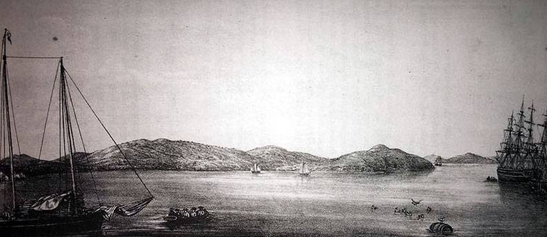
1837 lithograph of Yerba Buena Cove by Jean Vioget.
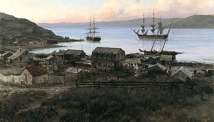
Painting by Christopher Blossom is titled "San Francisco on the eve of the Gold Rush, 1847.
Image: courtesy John Harris via Facebook
In late 1832, the Mexican Government appointed Jose Figueroa to be the Governor of Alta California. Figueroa was of Spanish and Aztec descent. He was proud of his Indian heritage. As a soldier on the Sonoran frontier, he rose to the rank of brigadier general. Now as the new Governor, his task was nearly impossible. And his heritage may have been a factor in the selection. Without any significant money, Figueroa was to renew the confidence of the Californios in the Mexican Government, keep the expansion of the Russians and Americans in check and, finally, take the thriving missions away from the Franciscans. They were to be turned over to the Indian converts and other private parties. This last task was euphemistically referred to as "secularization."
One of Figueroa's major assets was the 26 year old commandant of the Presidio de San Francisco, Lieutenant Mariano Vallejo. The precocious Vallejo had been the personal secretary to Governor Luis Arguello at 15, a member of the Alta California Legislature, the Deputacion, at 19 and a hero of the Mexican wars with the Native Americans at 22. Then a second lieutenant, Vallejo led 150 soldiers and stopped the 1829 Miwok revolt lead by the Yokut Indian, Cucunuchi, called "Estanislao" by the Mexicans. The battle at the Stanislaus River was the Mexicans' fourth try to subdue Cucunuchi's formidable forces.
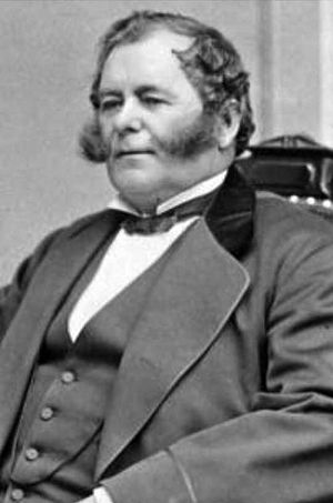
Mariano Vallejo.
In 1833, Figueroa ordered Vallejo to begin to reconnoiter the areas north of San Francisco. The purpose was to establish a new Presidio closer to the Russian settlement at Fort Ross. It was to be a bulwark against further Russian encroachment into Alta California. In 1834, Vallejo recommended that the San Francisco Presidio be moved to Sonoma near the Mission San Francisco Solano. It had been built and dedicated ten years earlier in 1824. By 1835, the move was accomplished and a new military outpost established next to the Mission San Francisco Solano in Sonoma. The San Francisco Presidio became nearly derelict.
On October 24, 1834, Vallejo recommended that a pueblo be established at Yerba Buena Cove. In response, on November 4, 1834, Figueroa wrote: "the Most Excellent Territorial Diputacion ... has adopted entire the plan you have presented ... with respect to the pueblo of San Francisco ... [p] This government, as proof of the confidence with which your services inspire it, has directed that you should have the honor of installing the first ayuntamiento in that pueblo of San Francisco, for which you have already done so much. ... [p] In consequence, you will proceed in the time and manner prescribed by law, in the election of the municipal authorities, in order that they may be installed the first day of January of the coming year, 1835, designating for town houses the buildings which you deem most fit."†
When the Presidio garrison moved to Sonoma in late 1835, some of the military families moved to the new pueblo in Yerba Buena Cove. The southern boundary of the new pueblo, known as the "Vallejo line," was from "Steamboat Point on the south side of Rincon Point (Fourth and Berry streets) to the Divisadero (Lone Mountain); thence to the south side of Point Lobos." †† On December 7, 1834, at Vallejo's home in the Presidio, an election was held at which eleven (11) electors were chosen. As previously noted, Juana Briones' father, brother and husband were among them.
On December 14, 1834, the electors voted for the ayuntamiento: (1) Francisco de Haro was elected as the first Alcalde of the Pueblo de Yerba Buena. De Haro was a 43 year old soldier who had been assigned to the Presidio since 1819; (2) Francisco Sanchez was elected the Secretary to the Alcalde. Sanchez was also a presidial soldier. His grandfather was a member of the de Anza expedition; and, (3) a six person district council was elected. The alcalde system of government originated in Islamic and Christian Spain. Not based on a separation of powers, it vested a lot of functions in the alcalde. He exercised civil and criminal executive and judicial powers.
On June 25, 1835, Richardson, his wife Maria Antonia and their three children arrived in Yerba Buena Cove. The shore line of the Bay ran south from the foot of Loma Alta (Telegraph Hill) to Rincon Point, along today's Montgomery St. At the time, Candelerio Miramontes, Juana Briones' brother-in-law, had an Irish potato patch where Portsmouth Square is located. There was a well-worn landing area at Clark's Point (Battery and Broadway Streets) used by ships' crews embarking and disembarking shuttle craft to and from ships at the anchorage. And there were some horse trails leading to two roads, one to the Presidio via Black Point (Fort Mason) and the other leading to Mission Dolores along Mission Creek.
Richardson chose a small rise above Portsmouth Square at today's Grant Avenue and Washington Street. There he erected a tent comprised of ship's sails stretched over four redwood posts. Yerba Buena was mostly sand dunes and small Toyon trees. There were lots of wild animals around such as bears, wolves and coyotes. Said Richardson's young daughter, Mariana: "...[O]ne night a bear put his paw under the tent and carried off a screeching rooster. My father killed the bear a few days later."
There Richardson sat awaiting news from Figueroa and Vallejo. Such was the humble beginnings of the great City and County of San Francisco. In 1836, the new Port of San Francisco represented an excellent opportunity for its two residents, Captain William Richardson and Juana Briones. Soon a third businessman arrived to capitalize on the situation. His name was Jacob Primer Leese. Leese was a young American who had entered into a business partnership with two other Yankees, Nathan Spear and Captain William Hinckley. Spear had a retail shop in Monterey. Hinckley was an active ship's captain in the coastwise trade. Indeed, on July 2, 1836, Captain Hinckley arrived in Yerba Buena Cove on the ship Don Quixote that carried merchandise for the new venture.
The Yerba Buena business opportunity was multifaceted. To start with, there was the hide and tallow export business. The Bay Area was rimmed with ranchos. The rancheros had large amounts of hides and tallow for sale to the ships that called at the port. Richardson was already in the logistics business to facilitate this trade. His two schooners were manned by his Indian employees carrying hides and tallow from Missions San Jose and Santa Clara to Yerba Buena Cove. Now that the Cove was the official Port, it became the central location to warehouse and otherwise trade the freight from some 20 ships per year.
Then there was the ship chandlery business, namely, selling merchandise to ships. The goods can be any of the many locally produced and imported ones such as whiskey, wine, beer, cloth, soap, leather, wool, tobacco, salt and other dry goods. The ships were also in the market for fresh water, fruit and produce, eggs, potatoes and other produce available from Juana Briones, Candelario Miramontes and the Missions. Richardson actually traded in the goods. As captain of the Port, it was his duty to board the ships on arrival. He also sometimes piloted ships from the Golden Gate to Yerba Buena Cove. He was in a great position to make a sale and even take an order.
There was also the business of catering to the needs of the ship's crew. Many of the ship's diarists mention persons who had fresh horses for rent on the shores of Yerba Buena Cove. Ship's officers and crews would often ride out to Mission Dolores or even to Buri Buri, Mission Santa Clara or Mission San Jose. The oldest and biggest ranchos were Mission Dolores, Mission San Jose and Mission Santa Clara. But in 1836, the Missions were in great turmoil. And one must look back into the history of the missions to understand why.
Back in 1765, King Carlos III, the last of the Spanish Bourbons, decided that the time had come to settle Alta California. This was something the Spanish had not done in the 236 years since they claimed the territory. The fear was that unless Spain settled Alta California, some other country would seize it. The Spanish called the settlement of Alta California the "Sacred Expedition." The plan envisioned that settlement would be achieved by the Franciscan Order of the Catholic Church. They would evangelize and convert the Native Americans up and down the coast to Catholicism. Like all good missionaries, they would build missions to house and "civilize" the new flock. This would settle the territory.
The plan was to be executed by a triumvirate: a statesman, Jose de Galves, a military explorer, Gaspar de Portola, and a Franciscan priest, St. Junipero Serra. The settlement of Alta California by building missions, 21 in all, started in 1769 with the establishment of the southernmost Mission San Diego de Alcala. It was built on the land of the Tipai-Ipai Indians alongside a small bend in the San Diego River just before it reaches the Pacific Ocean. The mission plan ended in 1823 with the northernmost Mission San Francisco Solano. This mission was built on the land of the Coast Miwok and Pomo Indians at the southern tip of the Valley of the Moon in Sonoma.
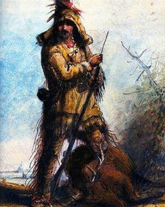
Early California bear wrangler
During the period 1769 to 1833, the missions became the backbone of the economic infrastructure of Alta California. They were a big part of the hide and tallow export and ship related business of the territory. As they became large and profitable, everyone wanted to know who really owned them and why. By 1821, the new Republican Government of Mexico viewed the missions through Enlightenment eyes. The Mexicans didn't like the excessive church and state entanglement that characterized them. Their business model was based on the enslavement of the Native Americans which servitude was enforced by the military. This was unacceptable for lots of reasons. These factors led the Mexicans to enact secularization laws.
On August 17, 1833, Mexico enacted a law entitled "An Act for the Secularization of the Missions of California." Beginning in 1834 and ending in 1836, the missions were secularized by selling off their lands. It set off a virtual land rush for the best mission properties. As well, Governor Alvarado began placing his favorite people in lucrative trusteeships designed to "oversee" the privatization. Vallejo was made the comisionado or administrator of the disposition of the lands of the Mission San Francisco Solano. Between 1833 and 1846, more than 500 grants of mission properties were made.
In August 1834, the U.S. delegation in Mexico City approached the Mexican Government with an offer of $5 million to buy the San Francisco Bay Area. The U.S. said it wanted a home base for American whalers in the Pacific. Since Alta California was still an outpost, the Mexicans seriously considered the offer. Apparently, British diplomats convinced them to hold onto the strategically located and prosperous bay. Now, in October 1835, Alcalde Francisco de Haro and the Yerba Buena ayuntamiento were meeting at William Richardson's tent in Yerba Buena Cove to design the City.
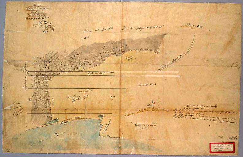
On a sunny October day, they surveyed the sand dunes along the Yerba Buena Cove waterfront to describe the metes and bounds of the new port city. They started by allocating an area to be the government's setback. It was a zone going all along the water's edge of Yerba Buena Cove north to south. It then went 200 varas (183.3 yards) west from the water's edge. The water's edge was the eastern boundary of the new town and ran along today's Montgomery Street. The two thoughts behind the 200 varas setback were that the government needed a customs house and the open, visible area would discourage smuggling.
Original William Richardson map of Yerba Buena Cove.
Image: Online History of California
As early as 1835, smuggling was a problem for the Mexican Government in Alta California. It had simply put too high a price on honesty. First, the government required all imports to clear customs in only one port, variously Monterey or San Diego. The imports would then have to be transported to, and landed in, the port of destination if it was other than the designated customs port. This required ships to duplicate nautical miles for freight destined elsewhere. Second, the customs duty on imports was often a high percentage of the value of the goods. It sometimes reached as high as 100%. Consequently, most Californios would cheat. They would discharge cargo at night, or land freight in a hidden cove to be retrieved later, or engage in other nefarious and clandestine dodges. Even Vallejo engaged in smuggling.
After creating the government setback, de Haro, the ayuntamiento and Richardson walked another 200 varas distance to the west to stand atop a sand dune. De Haro told Richardson that this sand dune would be the starting point to reckon the City's first main thoroughfare and private lots. The sand dune was located at today's Kearny Street between Pine and California Streets. This would be near the southwestern side of the Bank of America building at 555 California Street.
From this point, de Haro walked in a northwesterly direction toward the Presidio Road (toward today's North Beach) and stepped off five 100 vara lots. Richardson chose the fifth stepped-off lot to be his own. De Haro also declared that the land in a northwesterly direction all the way to the water's edge at the northern tip of North Beach would be the City's northwest boundary. And he announced that the main thoroughfare would run along the eastern boundary of the five lots and be called the "Calle de la Fundacion." De Haro then walked off another 200 varas to the southwest toward the Mission Road as the southwest boundary. All present agreed that the small village would be called Yerba Buena.
After his day with de Haro and the ayuntamiento, Richardson drew up the first survey or map of Yerba Buena. He made two copies of the October 1835 document, sending one to Monterey and keeping one for himself. A copy of Richardson's Yerba Buena map is attached. On October 20, 1835, Governor Jose Castro made the foundation of the City official. But he changed the name to "La Yerba Buena" and referred to it as the "Port of San Francisco." Wrote Castro: "The government ... has approved the plan which you have formed for the commencement of said village; which ... will be borne in mind in cases of granting lots to the individuals who may solicit them." At the end of October, Richardson moved his family to their new Calle de la Fundacion digs and began building a three room wooden house.
In 1836, Juana Briones built an adobe house on the western side of Alta Loma (Telegraph Hill). It was located at today's Powell and Filbert Streets. As de Haro had designated, it was within the boundaries of La Yerba Buena. There, Juana and her children ran a farm. She produced and sold milk, eggs and fresh fruits and vegetables to the ships at anchor in Yerba Buena Cove. After the terribly long voyages of the day, the first thing a ship's captain wanted to do was get fresh subsistence to the crew. Described as a "buxom, dark-faced lady," Juana had little competition for this profitable business.
In January 1835, Francisco de Haro started his term as Alcalde of the Pueblo de Yerba Buena. He was the first Alcalde in a long line of Alcaldes and Mayors who have led the City. De Haro had come to the Presidio de San Francisco as a soldier with the rank of Lieutenant in 1819. After he had taken part in various military exercises, he was elected as the secretary of the newly created Mexican territorial diputacion in 1822. His wife was the former Josefa Sanchez and they had twins sons, Francisco and Ramon. Don Francisco and his family were then living at Mission Dolores.
In late 1835, Governor Figueroa had instructed de Haro to develop Yerba Buena Cove into a commercial town and trading port. This had been the suggestion of the commandant of the Presidio, Lieutenant Mariano Vallejo. Vallejo and his men prepared to move the Presidio to Sonoma to place a buttress on the doorstep of the Russians at Fort Ross. As the Presidio diminished in favor of Sonoma, Yerba Buena rose as a town on the water's edge at the best anchorage in the Bay. Some twenty (20) ships per year were calling at San Francisco and now Yerba Buena Cove was the official anchorage.
Governor Figueroa hired Captain William Richardson to be Yerba Buena's first port captain. Richardson was arguably the best local mariner in Alta California. And no one was more familiar with San Francisco Bay. Richardson, his wife and three children had arrived in Yerba Buena Cove in June 1835. They pitched their tent and awaited further orders.
In the meantime, Richardson deactivated two old 30 ton schooners, the San Francisco and the Guadalupe. He had laid them up before he left for San Gabriel back in 1829. As soon as the schooners were ready, Richardson brought on Indian crews and began again to ferry people and goods around the Bay. He helped Vallejo move goods and materials from the Presidio to the North Bay. He also set up a transport and warehousing business. He would bring hides and tallow to the Cove, stored them, presumably on his schooners, and load them aboard outbound ships.
Shortly after he arrived, Richardson had a conversation with his father-in-law, Ignacio Martinez. Don Ignacio had been the commandant of the Presidio before Vallejo. He had a long and distinguished career as a loyal soldier of Spain and Mexico in Alta California. He would soon be the pardone of an 18,000 acre land grant rancho, Rancho El Pinole on Suisun Bay. Richardson gave a proposed sketch of the pueblo to Don Ignacio and warned him that the area was "very scarce of water."
During the summer, Jacob Leese arrived by ship in Yerba Buena. Richardson had met the 24-year-old Leese in San Gabriel. The American explained to Richardson that he had a business plan to open a trading store in the Cove in partnership with William Hinckley and Nathan Spear. Though Richardson was skeptical, Leese was on the next ship bound for Monterey. There he would petition the territorial government for permission to establish the planned trading operation in the newly minted pueblo.
In late summer 1835, a surprising turn of events changed quite a few fortunes. In August, the highly regarded Governor Figueroa began to suffer severe coronary pains. He summoned Richardson on the theory that he might be able to provide medical help. But before Richardson arrived in Monterey, in September, Figueroa died of a stroke and brain hemorrhage. Just before his death, Figueroa had appointed Jose Castro, the senior member of the Diputacion, to be acting Governor. Richardson and Castro discussed Figueroa's plans for a new pueblo at Yerba Buena Cove. Castro told him to await further word.
Then in October 1835, Richardson heard from Alcalde de Haro. Don Francisco had a letter from Monterey directing him to map a small village in Yerba Buena Cove. A couple of days later, Don Francisco and the ayuntamiento arrived at the Richardsons' tent. You'll recall that the tent was located on a small rise above today's Portsmouth Square at Grant Avenue and Washington St. Don Francisco told Richardson that he and the ayuntamiento were ready to do three things: (1) set out the parameters of the new Pueblo; (2) choose the government's property location; and, (3) designate Richardson's own 100 vara lot that Figueroa had agreed to give him. A vara is thirty-three inches, three inches short of a yard.
†With trivial omissions as indicated, this is otherwise a verbatim quote of parts of the translation of Figueroa's letter to Vallejo dated November 4, 1834 that appears in Zoeth Skinner Eldredge, The Beginnings of San Francisco, Scholar Select (1912) Vol. 2 at 501-502.
†† The quote is taken from Zoeth Skinner Eldredge, The Beginnings of San Francisco, Scholar Select (1912) Vol. 2 at 502.
Authorities for this material are: (1) Kevin Starr, California, The Modern Library (Paperback) (2007); (2) William Heath Davis, Sixty Years in California, A. J. Leary (San Francisco) (1889) reproduced by BiblioLife, LLC; (3) Langellier and Rosen, El Presidio de San Francisco, Arthur H. Clark Co. (1996) which is annotated to original sources; (4) Peter Browning (Editor), Yerba Buena San Francisco 1769-1849, Great West Books (1998) which contains original sources; (5) Zoeth Skinner Eldridge, The Beginnings of San Francisco, Scholar Select (1912); (6) Richard Henry Dana, Two Years Before The Mast, Seven Treasures Publications (2008); (7) W. W. Robinson, Land In California, University of California Press (paperback 1979); and, (8) Bernard DeVoto, Across the Wide Missouri, Houghton Mifflin Company (1998, Mariner Books edition). Special thanks to historian Jay Greene.

