Rincon Hill: Difference between revisions
m (credit) |
(added copy of Henry Miller mansion here) |
||
| (8 intermediate revisions by the same user not shown) | |||
| Line 1: | Line 1: | ||
'''<font face = Papyrus> <font color = maroon> <font size = 4>Historical Essay</font></font> </font>''' | |||
''by Northern California Coalition on Immigrant Rights'' | |||
[[Image:Boys-atop-rincon-hill-c-1870s-CHS2010.292.jpg]] | |||
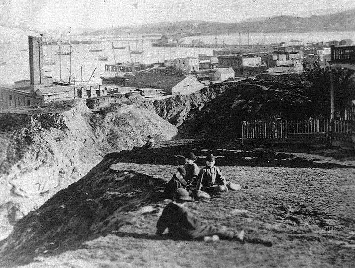
'''Three boys sit atop Rincon Hill, [[Staking Out Potrero Hill|Long Bridge]] crossing the mouth of Mission Bay in distance, c. 1870s.''' | |||
''Photo: California Historical Society'' | |||
[[Image:soma1$2nd-street-before-cut.jpg]] | [[Image:soma1$2nd-street-before-cut.jpg]] | ||
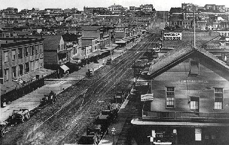
'''2nd Street from Market, looking south, 1866, Rincon Hill rises at end.''' | '''2nd Street from Market, looking south, 1866, Rincon Hill rises at end.''' ''Photo: California Historical Society, San Francisco, CA'' | ||
The word "Rincon" means "inside corner" in Spanish. Before the 1860s the area surrounding Rincon Center was a cove that extended to what is now First Street. Rincon is the name that was given to the hill at the inside corner of the cove. In the early 1850s, wealthy pioneers built large homes on the crest of Rincon Hill, chosen for its views of the city. Noted author Bret Harte lived on Silver Street. Recent excavations in the area also provide evidence of Chinese entrepreneurship in the 1880s when they set up small businesses, including laundries, and small supply stories to serve the needs of the boarding house residents and others working at the docks on the South side of the Hill. Some of these artifacts can be seen in the Rincon Center display cases. The Chinese also had a small fishing village in this area. This village disappeared along with South Beach when the area was filled in the late 1860s. In 1868, they cut Second Street across the hill, which made it no longer a desirable place for the wealthy, who moved to Nob Hill and other neighborhoods to the north. Homes were turned into rooming houses, and many warehouses and hospitals, including Irish, German, French, British, Italian and Swiss hospitals, were built. With the development of the city, however, parts of Rincon Hill were cut down and much of this property was lost. The fire of 1906 wiped out the remaining vestiges of the formerly wealthy neighborhood. What still exists of the hill is largely hidden beneath the entrance to the Bay Bridge. | The word "Rincon" means "inside corner" in Spanish. Before the 1860s the area surrounding Rincon Center was a cove that extended to what is now First Street. Rincon is the name that was given to the hill at the inside corner of the cove. In the early 1850s, wealthy pioneers built large homes on the crest of Rincon Hill, chosen for its views of the city. Noted author Bret Harte lived on Silver Street. Recent excavations in the area also provide evidence of Chinese entrepreneurship in the 1880s when they set up small businesses, including laundries, and small supply stories to serve the needs of the boarding house residents and others working at the docks on the South side of the Hill. Some of these artifacts can be seen in the Rincon Center display cases. The Chinese also had a [[Chinese shrimping village|small fishing village]] in this area. This village disappeared along with South Beach when the area was filled in the late 1860s. In 1868, they [[2nd St. Cut|cut Second Street]] across the hill, which made it no longer a desirable place for the wealthy, who moved to Nob Hill and other neighborhoods to the north. Homes were turned into rooming houses, and many warehouses and hospitals, including Irish, German, French, British, Italian and Swiss hospitals, were built. With the development of the city, however, parts of Rincon Hill were cut down and much of this property was lost. The fire of 1906 wiped out the remaining vestiges of the formerly wealthy neighborhood. What still exists of the hill is largely hidden beneath the entrance to the Bay Bridge. | ||
Rincon Hill had also been the bastion of the industrial and shipping bosses. As they began to move out and maritime unions became increasingly strong, union leaders began to live in that area and SOMA in general. In their successful heyday, the built several large union halls, and then sadly, over time, began to watch their influence start to fade in the 1950's until today, when there is largely no maritime industry at all. | Rincon Hill had also been the bastion of the industrial and shipping bosses. As they began to move out and maritime unions became increasingly strong, union leaders began to live in that area and SOMA in general. In their successful heyday, the built several large union halls, and then sadly, over time, began to watch their influence start to fade in the 1950's until today, when there is largely no maritime industry at all. | ||
''- | [[Image:Harrison near Essex circa 1865 opensfhistory wnp37.03473.jpg|800px]] | ||
'''Harrison near Essex Street, circa 1865. This intersection today is an entry point to the Bay Bridge.''' | |||
''Photo: OpenSFHistory.org wnp37.03473'' | |||
[[Image:View southwest to 555 Harrison Street, Harrison at Essex-- Rincon Hill home of Benjamin Horn c1865 opensfhistory wnp26.491.jpg|800px]] | |||
'''View southwest to 555 Harrison Street, Harrison at Essex—Rincon Hill home of Benjamin Horn c. 1865.''' | |||
''Photo: OpenSFhistory wnp26.491'' | |||
[[Image:Henry-Millers-mansion-1882-Rincon-Hill Harrison-and-Essex-until-1906.jpg]] | |||
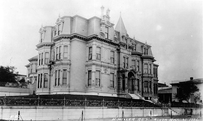
'''[[Miller & Lux and the Dirty Plate Route|Henry Miller]]'s luxurious mansion on Rincon Hill, occupying the corner of Harrison and Essex from 1882 until it burned down in the fire of 1906.''' | |||
''Photo: San Francisco History Center, San Francisco Public Library'' | |||
[[Image:View East on Harrison from Essex-- Pier 24 is visible in the distance oct 18 1915 opensfhistory wnp36.01016.jpg|800px]] | |||
'''View East on Harrison from Essex—Pier 24 is visible in the distance, October 18, 1915.''' | |||
''Photo: OpenSFhistory wnp36.01016'' | |||
[[Image:Harrison and Essex Apr 3, 1919 opensfhistory wnp36.02092.jpg|800px]] | |||
'''Harrison and Essex, April 3, 1919.''' | |||
''Photo: OpenSFhistory wnp36.02092'' | |||
[[Image:View West on Harrison from Essex, A Fleishhacker and Company, The Paper Box House, on left at 2nd & Harrison June 1920 opensfhistory wnp36.02325.jpg|800px]] | |||
'''View West on [[Harrison Street from Dunes to Trains|Harrison]] from Essex, A. Fleishhacker and Company, The Paper Box House, on left at 2nd & Harrison, June 1920.''' | |||
''Photo: OpenSFhistory wnp36.02325'' | |||
[[Image:Harrison to 2nd Feb 11, 1919 400 2nd st w water tank still stands opensfhistory wnp36.02023.jpg|800px]] | |||
'''Harrison to 2nd Street, Feb 11, 1919. 400 2nd St. with water tank still stands in the 2020s.''' | |||
''Photo: OpenSFhistory wnp36.02023'' | |||
[[2nd St. Cut|South Park and Rincon Hill continues]] | |||
[[2nd St. Cut |Prev. Document]] [[SOUTH OF MARKET/SOMA |Next Document]] | |||
[[ | [[category:SOMA]] [[category:Power and Money]] [[category:1860s]] [[category:1880s]] [[category:1910s]] [[category:1920s]] [[category:Chinese]] [[category:Hills]] | ||
Latest revision as of 21:07, 29 April 2023
Historical Essay
by Northern California Coalition on Immigrant Rights
Three boys sit atop Rincon Hill, Long Bridge crossing the mouth of Mission Bay in distance, c. 1870s.
Photo: California Historical Society
2nd Street from Market, looking south, 1866, Rincon Hill rises at end. Photo: California Historical Society, San Francisco, CA
The word "Rincon" means "inside corner" in Spanish. Before the 1860s the area surrounding Rincon Center was a cove that extended to what is now First Street. Rincon is the name that was given to the hill at the inside corner of the cove. In the early 1850s, wealthy pioneers built large homes on the crest of Rincon Hill, chosen for its views of the city. Noted author Bret Harte lived on Silver Street. Recent excavations in the area also provide evidence of Chinese entrepreneurship in the 1880s when they set up small businesses, including laundries, and small supply stories to serve the needs of the boarding house residents and others working at the docks on the South side of the Hill. Some of these artifacts can be seen in the Rincon Center display cases. The Chinese also had a small fishing village in this area. This village disappeared along with South Beach when the area was filled in the late 1860s. In 1868, they cut Second Street across the hill, which made it no longer a desirable place for the wealthy, who moved to Nob Hill and other neighborhoods to the north. Homes were turned into rooming houses, and many warehouses and hospitals, including Irish, German, French, British, Italian and Swiss hospitals, were built. With the development of the city, however, parts of Rincon Hill were cut down and much of this property was lost. The fire of 1906 wiped out the remaining vestiges of the formerly wealthy neighborhood. What still exists of the hill is largely hidden beneath the entrance to the Bay Bridge.
Rincon Hill had also been the bastion of the industrial and shipping bosses. As they began to move out and maritime unions became increasingly strong, union leaders began to live in that area and SOMA in general. In their successful heyday, the built several large union halls, and then sadly, over time, began to watch their influence start to fade in the 1950's until today, when there is largely no maritime industry at all.
Harrison near Essex Street, circa 1865. This intersection today is an entry point to the Bay Bridge.
Photo: OpenSFHistory.org wnp37.03473
View southwest to 555 Harrison Street, Harrison at Essex—Rincon Hill home of Benjamin Horn c. 1865.
Photo: OpenSFhistory wnp26.491
Henry Miller's luxurious mansion on Rincon Hill, occupying the corner of Harrison and Essex from 1882 until it burned down in the fire of 1906.
Photo: San Francisco History Center, San Francisco Public Library
View East on Harrison from Essex—Pier 24 is visible in the distance, October 18, 1915.
Photo: OpenSFhistory wnp36.01016
Harrison and Essex, April 3, 1919.
Photo: OpenSFhistory wnp36.02092
View West on Harrison from Essex, A. Fleishhacker and Company, The Paper Box House, on left at 2nd & Harrison, June 1920.
Photo: OpenSFhistory wnp36.02325
Harrison to 2nd Street, Feb 11, 1919. 400 2nd St. with water tank still stands in the 2020s.
Photo: OpenSFhistory wnp36.02023


