Grand View Park photos: Difference between revisions
(added Charles Ruiz photos) |
m (Linking to Grand View Peak page.) |
||
| (3 intermediate revisions by 3 users not shown) | |||
| Line 3: | Line 3: | ||
[[Image:Grand-view-peak-1930s.jpg]] | [[Image:Grand-view-peak-1930s.jpg]] | ||
'''Grand View Peak looking eastward from above, 1930s.''' | '''[[Grand View Peak|Grand View Peak]] looking eastward from above, 1930s.''' | ||
''Photo: Private Collection, San Francisco, CA'' | ''Photo: Private Collection, San Francisco, CA'' | ||
[[Image: | [[Image:Grand View Peak wnp36.03585.jpg]] | ||
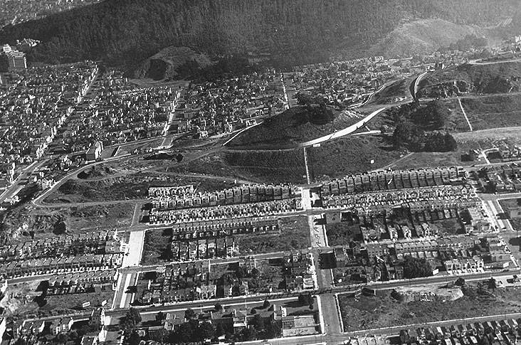
'''Grand View Peak getting its infrastructure in place, making it ready for urbanization and development. Moraga Street got a special staircase on the east side.''' | '''Grand View Peak getting its infrastructure in place in 1928, making it ready for urbanization and development. Moraga Street got a special staircase on the east side.''' | ||
''Photo: | ''Photo: OpenSFHistory/wnp36.03585.jpg'' | ||
[[Image:6th-Ave-west-from-near-Lawton-w-7th-ave-in-foreground-and-Grand-View-Peak-at-left-1921.jpg|720px]] | [[Image:6th-Ave-west-from-near-Lawton-w-7th-ave-in-foreground-and-Grand-View-Peak-at-left-1921.jpg|720px]] | ||
| Line 17: | Line 17: | ||
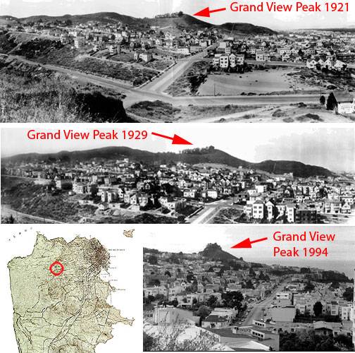
'''View from 6th Avenue westward on Lawton, 7th Avenue in foreground and Grand View Peak at left, 1921.''' | '''View from 6th Avenue westward on Lawton, 7th Avenue in foreground and Grand View Peak at left, 1921.''' | ||
''Photo: | ''Photo: San Francisco History Center, San Francisco Public Library'' | ||
[[Image:6th-ave-and-lawton-3-up.jpg]] | [[Image:6th-ave-and-lawton-3-up.jpg]] | ||
| Line 28: | Line 28: | ||
''Photos: Chris Carlsson'' | ''Photos: Chris Carlsson'' | ||
[[Image:Golden Gate Heights relief map wnp36.03083.jpg]] | |||
'''Map of Golden Gate Heights, July 27, 1923.''' | |||
''Photo: [http://opensfhistory.org/Display/wnp36.03083.jpg OpenSFHistory.org, wnp36.03083]; DPW Horace Chaffee (SF Department of Public Works / Courtesy of a Private Collector)'' | |||
Latest revision as of 19:29, 11 April 2023
Unfinished History
Grand View Peak looking eastward from above, 1930s.
Photo: Private Collection, San Francisco, CA
Grand View Peak getting its infrastructure in place in 1928, making it ready for urbanization and development. Moraga Street got a special staircase on the east side.
Photo: OpenSFHistory/wnp36.03585.jpg
View from 6th Avenue westward on Lawton, 7th Avenue in foreground and Grand View Peak at left, 1921.
Photo: San Francisco History Center, San Francisco Public Library
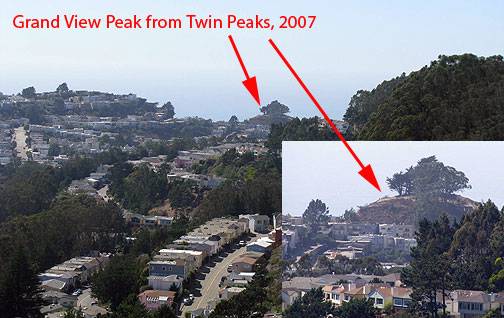
View from 6th Avenue westward on Lawton.
Photos: Private Collection, San Francisco, CA
Photos: Chris Carlsson
Map of Golden Gate Heights, July 27, 1923.
Photo: OpenSFHistory.org, wnp36.03083; DPW Horace Chaffee (SF Department of Public Works / Courtesy of a Private Collector)


