St Mary's Development: Difference between revisions
(added link to source) |
Ncollister (talk | contribs) No edit summary |
||
| Line 3: | Line 3: | ||
[[Image:excelvis$silver-avenue-east-view-1925.jpg|720px|thumb]] | [[Image:excelvis$silver-avenue-east-view-1925.jpg|720px|thumb]] | ||
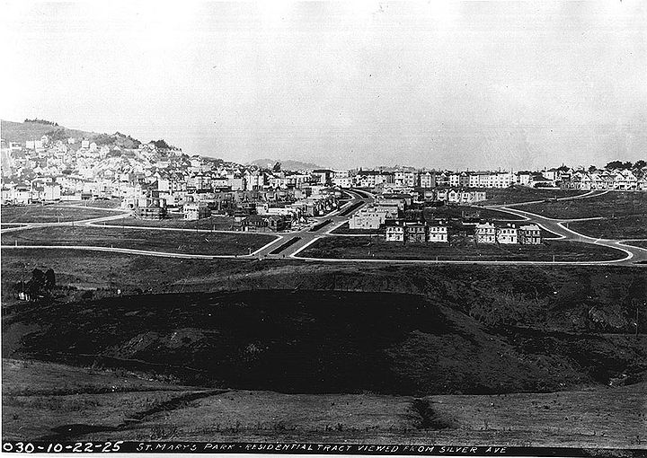
'''Silver Avenue view: 1925 northeastward towards the new St Mary's Residential Tract southwest of Bernal Heights | '''Silver Avenue view: 1925 northeastward towards the new St Mary's Residential Tract southwest of Bernal Heights''' | ||
''Private Collection, San Francisco, CA'' | ''Private Collection, San Francisco, CA'' | ||
In 1855, [[Joseph Alemany | Joseph Alemany]], first archbishop of San Francisco, acquired a tract of land near Hayes and Polk streets for the site of a new college | In 1855, [[Joseph Alemany | Joseph Alemany]], first archbishop of San Francisco, acquired a tract of land near Hayes and Polk streets for the site of a new diocesan college. However, the increased congestion in the rapidly expanding city forced Alemany to the "country" south of San Francisco, where he bought 60 acres of Rancho Rincon de la Salinas y Potrero Viejo from Jesus Bernal (son of José Bernal) for $1,600. | ||
In 1863, the newly christened St. Mary's College opened its doors on the land acquired from Jesus Bernal. This first campus was short-lived: in 1889, the college moved to a new location in Oakland, eventually relocating again to its current location in Moraga in 1928. | |||
For a time, the former college site found new life as St. John's Parish, established by Alemany's successor, Archbishop Riordan. In the early 1900s, it also housed a truck farm, providing fruits and vegetables to the growing city. | |||
In 1924, the land was surveyed and opened for subdivision. The architect Mark Daniels, known for his work on the residential parks of Sea Cliff and Forest Hill, was brought on to design the new future neighborhood. | |||
To honor the history of St. Mary’s college, Daniels laid out the streets of the neighborhood in the shape of a bell. Justin, Agnon, and Genebern streets were named after teaching brothers at the college, and the neighborhood was known henceforth as St. Mary’s Park. | |||
[[Image:St mary's park and alemany farm sf model-lisaruth elliott.jpg]] | [[Image:St mary's park and alemany farm sf model-lisaruth elliott.jpg]] | ||
| Line 20: | Line 22: | ||
''Photo: LisaRuth Elliott'' | ''Photo: LisaRuth Elliott'' | ||
Not long after the neighborhood’s first residents moved in, the city of San Francisco set aside 13 acres for a recreation area to the east, 10 of which it bought for $87,500, while the Archdiocese donated the remainder. | |||
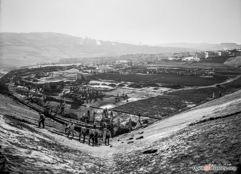
In the 1930s, the Works Progress Administration (WPA) employed job-seeking San Franciscans to shape the land in preparation for what would become [[St Mary's Recreation Center|St. Mary's Recreation Center]]. The park would sit atop three tiers along a steeply sloped hill: the first tier housing a gymnasium, auditorium, and baseball diamond, the second tier including a playground, tennis courts, and basketball court. | |||
The third tier is now the site of St. Mary’s Dog Park, which can be accessed by the footbridge over Highway 280. | |||
[[Image:1938 aerial of E edge of st. mary's park bell and of park and land E.png]] | [[Image:1938 aerial of E edge of st. mary's park bell and of park and land E.png]] | ||
| Line 25: | Line 33: | ||
'''Aerial photo from 1938 mentioned above, showing the east edge of the St. Mary's Bell.''' | '''Aerial photo from 1938 mentioned above, showing the east edge of the St. Mary's Bell.''' | ||
[[Image: | [[Image:Dec 26 1933 St. Mary's Park, later St. Mary's Recreation Center under construction. View south across Alemany Boulevard toward grading, houses on Crescent, Bernal Heightswnp14.2793.jpg|792px]] | ||
''' | '''Longer view of the St. Mary's Recreation Center Construction, December 26, 1933''' | ||
''Photo: OpenSFHistory.org, | ''photo: OpenSFHistory.org, wnp14.2793'' | ||
According to Clyde Healy, Assistant City Engineer and City of SF Coordinator of WPA projects, the [https://livingnewdeal.org/projects/saint-marys-playground-san-francisco-ca/ WPA] constructed St. Mary’s Playground first, broadening the neighborhood's appeal to San Franciscan families. | |||
Manual laborers graded the land, installing fencing, landscaping, and building concrete walls. The rest of the park was completed in the 1940s and 1950s, and the Recreation Center was formally established in 1952. | |||
[[Image:Jan 4 1934 St. Mary's Park, later St. Mary's Recreation Center, under construction. View Southwest toward the Excesior and McLaren Park. Men grading field by hand wnp14.2795.jpg|792px]] | |||
'''St. Mary's Recreation Center Construction, looking southwesterly from near Crescent and Justin, January 4, 1934.''' | |||
''Photo: OpenSFHistory.org wnp14.2795'' | |||
Today, St. Mary's Park is home to a diverse set of residents, many of whom have lived in the neighborhood for generations. Within the small bell-shaped neighborhood, traces of the former diocesan college campus remain. The most prominent is a historical marker on College Avenue, honoring the neighborhood's academic beginnings with a plaque, bell, and cross. | |||
Along the short stretch of Mission Street that runs through the area, local establishments St. Mary’s Pub and New College Hill Market have served neighbors for nearly a century, their names a nod to the former "college hill" in this quiet southeastern pocket of San Francisco. | |||
[[Image:St marys historical marker-nikki collister.jpg]] | |||
'''The historical marker at the western end of College Ave. was placed in 1962 by The California State Park Commission in cooperation with St. Mary’s College and the California Historical Society.''' | |||
''Photo: Nikki Collister'' | |||
Thanks to [http://www.50justin.com/stmaryspark.htm David Otero's website] on the history of St. Mary's Park. | |||
[[Philosopher's Way at McLaren Park |Prev. Document]] | [[Philosopher's Way at McLaren Park |Prev. Document]] [[Crocker Amazon Tract Notables | Next Document]] | ||
[[category:Excelsior]] [[category:1920s]] [[category:Bernal Heights]] [[category:1940s]] | [[category:Excelsior]] [[category:1920s]] [[category:Bernal Heights]] [[category:1940s]] | ||
Revision as of 09:47, 4 June 2023
Unfinished History
Silver Avenue view: 1925 northeastward towards the new St Mary's Residential Tract southwest of Bernal Heights
Private Collection, San Francisco, CA
In 1855, Joseph Alemany, first archbishop of San Francisco, acquired a tract of land near Hayes and Polk streets for the site of a new diocesan college. However, the increased congestion in the rapidly expanding city forced Alemany to the "country" south of San Francisco, where he bought 60 acres of Rancho Rincon de la Salinas y Potrero Viejo from Jesus Bernal (son of José Bernal) for $1,600.
In 1863, the newly christened St. Mary's College opened its doors on the land acquired from Jesus Bernal. This first campus was short-lived: in 1889, the college moved to a new location in Oakland, eventually relocating again to its current location in Moraga in 1928.
For a time, the former college site found new life as St. John's Parish, established by Alemany's successor, Archbishop Riordan. In the early 1900s, it also housed a truck farm, providing fruits and vegetables to the growing city.
In 1924, the land was surveyed and opened for subdivision. The architect Mark Daniels, known for his work on the residential parks of Sea Cliff and Forest Hill, was brought on to design the new future neighborhood.
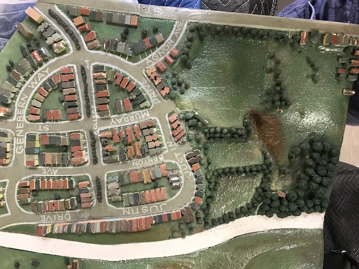
To honor the history of St. Mary’s college, Daniels laid out the streets of the neighborhood in the shape of a bell. Justin, Agnon, and Genebern streets were named after teaching brothers at the college, and the neighborhood was known henceforth as St. Mary’s Park.
A scale wooden model of San Francisco was built in 1940 from 1938 aerial photos taken of the whole peninsula, and the San Francisco Public Library and SFMOMA’s Public Knowledge project showcased portions of the model in library branches in 2019.
Photo: LisaRuth Elliott
Not long after the neighborhood’s first residents moved in, the city of San Francisco set aside 13 acres for a recreation area to the east, 10 of which it bought for $87,500, while the Archdiocese donated the remainder.
In the 1930s, the Works Progress Administration (WPA) employed job-seeking San Franciscans to shape the land in preparation for what would become St. Mary's Recreation Center. The park would sit atop three tiers along a steeply sloped hill: the first tier housing a gymnasium, auditorium, and baseball diamond, the second tier including a playground, tennis courts, and basketball court.
The third tier is now the site of St. Mary’s Dog Park, which can be accessed by the footbridge over Highway 280.
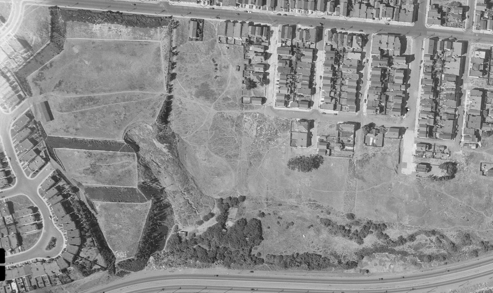
Aerial photo from 1938 mentioned above, showing the east edge of the St. Mary's Bell.
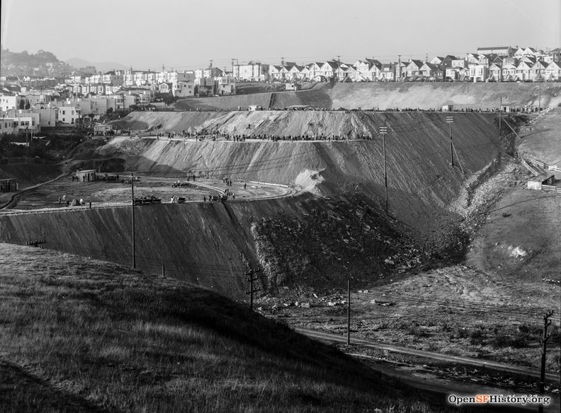
Longer view of the St. Mary's Recreation Center Construction, December 26, 1933
photo: OpenSFHistory.org, wnp14.2793
According to Clyde Healy, Assistant City Engineer and City of SF Coordinator of WPA projects, the WPA constructed St. Mary’s Playground first, broadening the neighborhood's appeal to San Franciscan families.
Manual laborers graded the land, installing fencing, landscaping, and building concrete walls. The rest of the park was completed in the 1940s and 1950s, and the Recreation Center was formally established in 1952.
St. Mary's Recreation Center Construction, looking southwesterly from near Crescent and Justin, January 4, 1934.
Photo: OpenSFHistory.org wnp14.2795
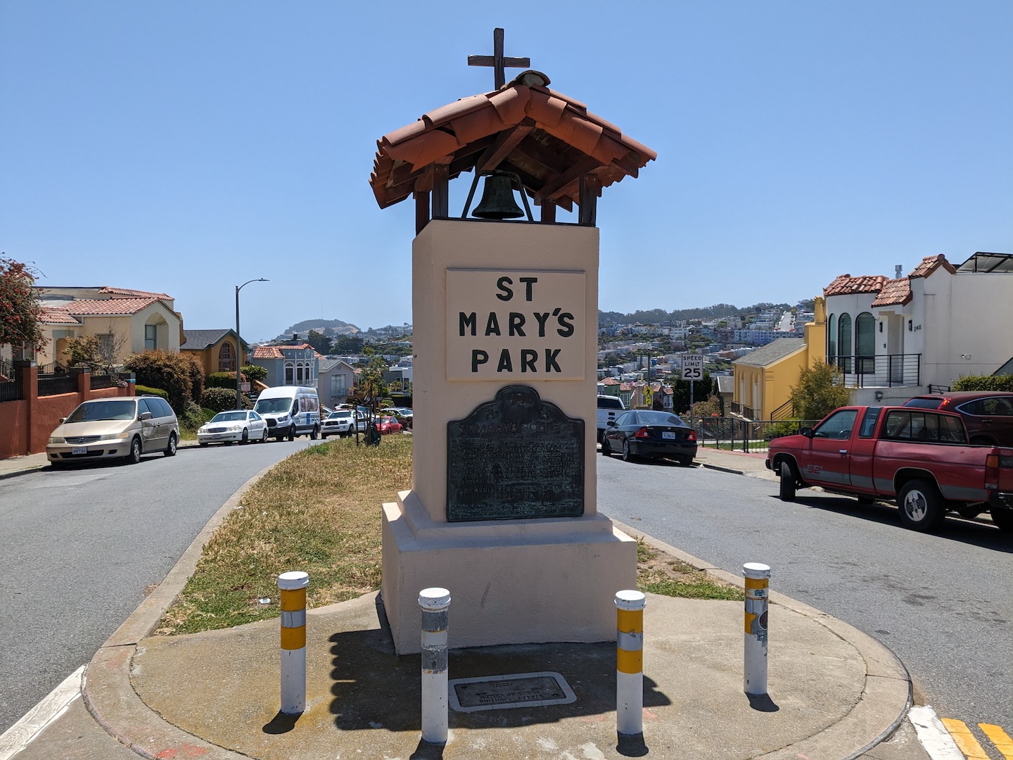
Today, St. Mary's Park is home to a diverse set of residents, many of whom have lived in the neighborhood for generations. Within the small bell-shaped neighborhood, traces of the former diocesan college campus remain. The most prominent is a historical marker on College Avenue, honoring the neighborhood's academic beginnings with a plaque, bell, and cross.
Along the short stretch of Mission Street that runs through the area, local establishments St. Mary’s Pub and New College Hill Market have served neighbors for nearly a century, their names a nod to the former "college hill" in this quiet southeastern pocket of San Francisco.
The historical marker at the western end of College Ave. was placed in 1962 by The California State Park Commission in cooperation with St. Mary’s College and the California Historical Society.
Photo: Nikki Collister
Thanks to David Otero's website on the history of St. Mary's Park.

