FoundSF
Menu
Navigation
Home
About FoundSF
Links
Random page
Log in
Search
What links here
Related changes
Special pages
Printable version
Permanent link
Page information
Recent changes
Help
Category
Discussion
View source
View history
Log in
Donate ♥
« shapingsf.org
Browse:
Decade
Neighborhood
Population
Theme
Tours
Give
What Links Here
Add to the Archive:
Add an Article
Edit Article
Upload Media
Donate via Flipcause
one time or monthly
or become a
Patreon patron
Maps: Difference between revisions
Revision as of 18:20, 18 January 2009
(
view source
)
Ccarlsson
(
talk
|
contribs
)
(New page:
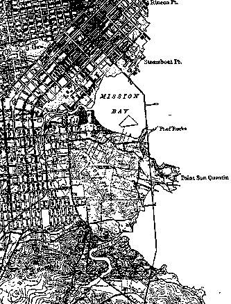
Image:pothill69-us-coast-survey-map.jpg
'''1869 U.S. Coast Survey Map. ''')
Revision as of 14:33, 20 January 2009
(
view source
)
Lisaruth
(
talk
|
contribs
)
m
(Protected "
Category:Maps
" [edit=sysop:move=sysop])
Newer edit →
(No difference)
Revision as of 14:33, 20 January 2009
1869 U.S. Coast Survey Map.
Pages in category "Maps"
The following 10 pages are in this category, out of 10 total.
B
Bernal's Name
Birdseye View of San Francisco 1878
C
Creating Gay Spaces: Spaces of Social and Sexual Freedom
L
La Lengua, 1907
M
Neighborhood/Geography
Mission Plank Road
P
PENINSULA TOUR FOR CITY WHEELMEN
Potrero Hill Historic Maps
S
South San Francisco Hillside Sign
U
Unraveling the Mystery of Lake Dolores
Share this page: