Problems of Waterfront Planning: Difference between revisions
No edit summary |
No edit summary |
||
| Line 95: | Line 95: | ||
[[category:shoreline]] [[category:downtown]] [[category:SOMA]] [[category:1990s]] [[category:2000s]] [[category:2010s]] [[category:1950s]] [[category:1900s]] [[category: | [[category:shoreline]] [[category:downtown]] [[category:SOMA]] [[category:1990s]] [[category:2000s]] [[category:2010s]] [[category:1950s]] [[category:1900s]][[category:Book Excerpts]] | ||
Latest revision as of 19:40, 29 November 2021
Historical Essay
by Jasper Rubin
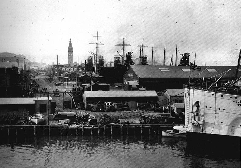
View north on East Street (now the Embarcadero) from Folsom Street, c. 1901-1905
Photo: Seaver Center for Western History Research, Los Angeles County Museum of Natural History
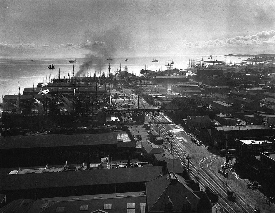
South view from Ferry Building down East Street (now Embarcadero) c. 1901-1905
Photo: Seaver Center for Western History Research, Los Angeles County Museum of Natural History
As one might surmise, the Waterfront Land Use Plan has not ended contention over development, or resulted in a magical transformation of the entirety of port property. Nor has it prevented the port from making dubious decisions regarding what projects to pursue. At the turn of the millennium, the agency was fairly well excoriated for choosing to pursue an "interactive" San Francisco history museum/amusement park at Shed A of Pier 45, proposed by Malrite, instead of a marine research center. The former had funding, lobbyists aplenty, and port support. The latter, proposed by the nonprofit Bay Center, a coalition of merchants and environmentalists led by Chris Martin of the Cannery, struggled to raise cash but was favored by most San Franciscans.(34) After nearly a year, the museum proposal, disliked by both Mayor Gavin Newsom and the board of supervisors, died an ugly political death. The research center was never able to secure sufficient funds to move forward.
Since adoption of the Waterfront Land Use Plan, two projects in particular—both large and complex, and destined for failure—have frustrated the port. The first was a proposal by San Francisco Cruise Terminal LLC, which was a partnership between Australian giant Bovis/Lend Lease and minority partner Port of Singapore, to develop a cruise terminal and 600,000 square feet of offices, retail, and commercial uses at Piers 30-32. The project also included seawall lot 330 across the Embarcadero from the piers, originally to be developed with hotel and retail. The basic concept was supported by the Waterfront Land Use Plan and enjoyed a fair amount of support from the public and city agencies. The public responded well to the cruise terminal, open space, access to the bay, and other amenities, and to the development team itself, which was considered creative and engaging.(35) However, even with the International Cruise Terminal as its focus, the proposal ran into public trust issues that required special state legislation to resolve. After engineering studies revealed that the cost to repair and seismically upgrade the piers was much higher than expected, the development team proposed that condos instead of hotels be built, but this involved the lengthy process of transferring the burden of the public trust from the seawall lot to property elsewhere.
The developers had all of their entitlements in hand and had secured the right to build the condominium tower first so that profits from that venture could support the cruise terminal and public spaces. However, even though the tower was completed at the height of the real estate boom in 2006, profits were insufficient to make the project financially feasible. Adding office space and a shopping arcade may have been enough to pay the $80 million needed to upgrade the piers and cover increased construction costs, but to do so would have made it un-approvable—politically and legally. Bovis/Lend Lease backed out of the project and actually left money on the table. Per the terms of the agreement, most of the profit from sales of condominiums would go to the port should the cruise terminal not be constructed.(36) This is the second place in which housing has been built on the waterfront. One more attempt was made at getting the cruise terminal built at Piers 30-32. Eddie DeBartolo, former owner of the 49ers football team, took a stab at making a project happen. His proposal shrank the size of the cruise terminal (though cruise ships were getting longer) and increased the amount of commercial space. The port rejected his bid in 2006 and appointed an advisory panel to seek alternative locations. Pier 27 is the current candidate, and the project is advancing.
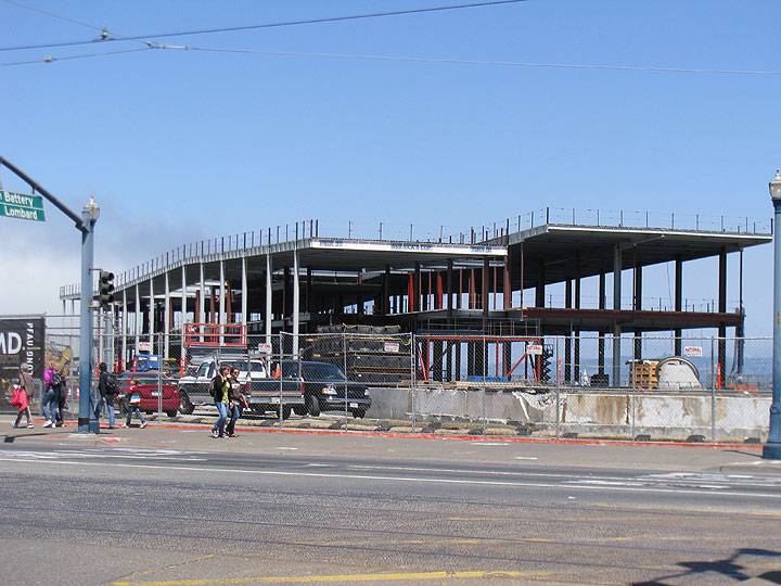
After this essay was written, the organizers of the America's Cup yacht race contracted with the Port and the City to build an arena and visitors' center at Pier 27, here under construction in August 2012.
Photo: Chris Carlsson
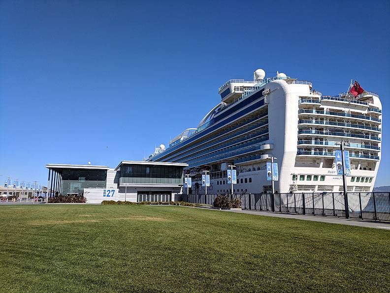
Ruby Princess cruise ship docked at Pier 27, years after the yacht race imbroglio, seen here November 5, 2018.
Photo: Chris Carlsson
A similar fate befell a proposal to develop a massive complex at Piers 27-31, at the base of Telegraph Hill. The Waterfront Land Use Plan identified the piers as an appropriate location to promote active recreation, retail, and other maritime activities. The port received two bids to its RFP, one from Chelsea Piers, responsible for the waterfront entertainment complex of the same name in New York, and one from Virginia-based Mills Corporation, known as a builder of shopping malls, teamed with the YMCA. After a contentious and politically heated selection process and nearly pugilistic tactics on both sides, the port selected Mills in 2001.(37) Mills' proposal was to create a mixed-used project to include 145,000 square feet of shops and restaurants, a 110,000-square-foot YMCA facility, boat ramps, and a plaza. Opponents of the project objected that the piers would end up another retail mecca and that transportation along the Embarcadero would suffer. The more dedicated and vociferous among them formed Citizens to Save the Waterfront, which, supported by Supervisor Aaron Peskin, successfully pressured Mills to change aspects of its project. The firm did so and the commission approved the revisions in 2004.(38)
The particular recreational uses proposed included indoor basketball courts, soccer fields, and a bowling alley. The SLC determined that these were inappropriate to a tidelands site, revealing an issue with the flexible approach taken in the Waterfront Land Use Plan with respect to programming potential land uses. Until specific proposals were made, thus clarifying the exact nature of "recreational enterprises" proposed, it was difficult to know how the SLC would react. This was a lesson learned for the port.
But even after refining the project proposal yet again to respond to SLC concerns, Mills could not rid itself of the controversy that had boiled and simmered for six years. The project also suffered from results of the local election cycle. Mayor Willie Brown, the sponsor's main backer in city hall, was replaced by Gavin Newsom, who was neutral toward the project. At that point, Mills had little political power left. Official support all but disappeared with the appointment in 2004 of Monique Moyer as port executive director. Known for her fiscal prudence, Moyer was cool to the project because it committed the port to a 66-year lease with less than stellar terms. So, after spending $21 million and several years in predevelopment, Mills sold their right to negotiate to a team headed by local real estate giant Shorenstein and Company early in 2006. The new sponsors replaced the retail component with office space. Only months after taking over the project, they insisted that it would take at least double the office space to pay for repairs to the piers necessary to support construction—the estimate had risen from $78 million to $145 million. This essentially killed the project because even in the unlikely event that the SLC would approve a major increase in offices (even to pay for trust uses) there would be no money left to provide the required public amenities.(39) The combination of restricted development potential and the cost of seismic upgrades in addition to the requirements for public amenities was too much.
It is not necessary here either to dig into the complexity of the cruise terminal project or the teeth-gnashing, maneuvering, and hardball politics that permeated the Mills project, or reveal the details of their land-use planning and financial intricacies to make the main point. In the port's own words, "it is clear that public-private partnership developments do not work in all instances. On the one hand, the qualities of rehabilitated historic maritime facilities, which incorporate generous amounts of public access and a diverse mix of activities—when they work—do produce enormous public benefits. . . . On the other hand, the balancing act required to contain development costs [for projects that have] relatively low development density and relative high public benefit and regulatory requirements, is very precarious."(40)
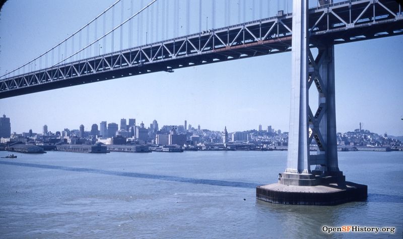
San Francisco shoreline view from under the Bay Bridge, 1954, when the Port was thriving, but its future was already being determined.
Photo: OpenSFHistory.org wnp25.6587
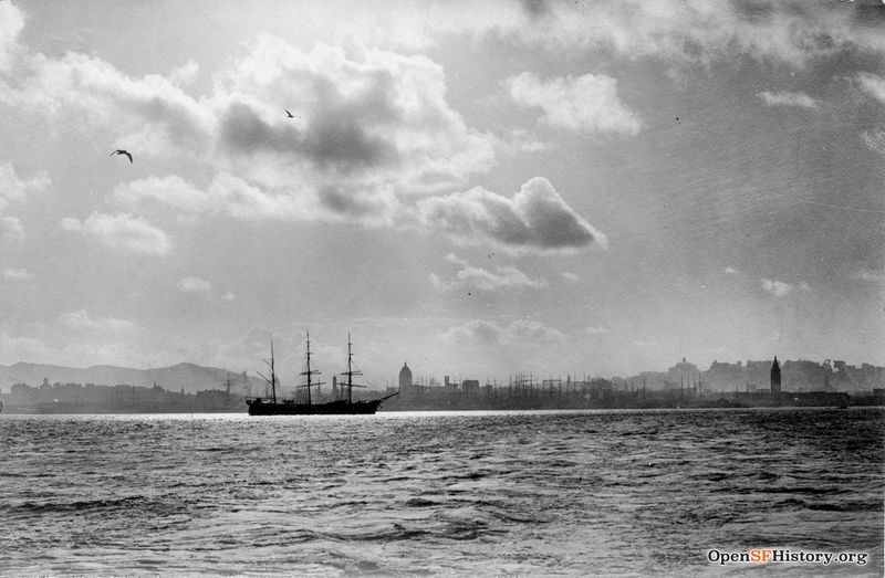
Similar view c. 1900, south of the Ferry Building, west towards the City's shoreline and port from the bay.
Photo: OpenSFHistory.org wnp27.7219
In the dozen or so years after the adoption of the Waterfront Land Use Plan the port has not been able to produce a single major commercial development using the public-private partnership formula of public real estate for private capital outside of the Ferry Building area. The failure of two difficult projects and the hard-won success of even a non-controversial one like the Ferry Building forced the port to reassess its approach. In fact, a new paradigm based on public financing has been ushered in. So far, it has met with success. Instrumental have been an energetic and creative staff and the current director of the port, Monique Moyer, considered by some to be one of the best public agency finance people in the country, and who has been extremely effective in negotiations with other city agencies and the state.
The foundations of the future are in a supplement to the Waterfront Land Use Plan—the Ten-Year Capital Plan. Published in 2006 and updated in 2008, it provides the public for the first time with a clear accounting of the port's maintenance, maritime, and development goals and the costs tied to each. The total for the balance sheet is a staggering 1.9 billion dollars, most of which is for deferred maintenance and seismic work and to clean up Pier 70 and rehabilitate its historic buildings. The port is searching for ways to pay this massive bill, with only some covered by public financing made available by ballot measures, legislation at the state level, and a city administration newly sensitive to the predicament of its port. What follows is a summary of the key components of the new public financing approach.
First, the port was able to convince the city's administration that it should be included in a general obligation bond proposal placed on the ballot. In fact, voters recently passed a proposition that included significant funding for port open space projects. This is the first time the city has used its bonding capacity to support port waterfront improvements.
Second, with support from state assembly member Carole Migden, who represented San Francisco, the port was able to push legislation through Sacramento in 2005 that has enabled the agency to create "Infrastructure Finance Districts." These districts will allow the port to capture tax increments from future developments and, instead of sending the income to city and state coffers, apply it to the provision of public amenities, reinvestment, and historic preservation. Third, in 2007, Governor Arnold Schwarzenegger signed Senate Bill 815. The bill was the outcome of a coordinated effort between state, regional, and local agencies, facilitated by negotiations with local activist organizations. It allows the port to remove public trust restrictions from certain seawall lots that no longer serve maritime purposes so that it will be able to pursue mixed-use projects—as long as return from the development is invested in historic preservation and provision of open space, community facilities, and other public benefits along the waterfront. Fourth, in November 2008, San Franciscans passed Proposition D, a measure that supports land-use planning for and rehabilitation of Pier 70 by allowing up to 75 percent of any new payroll and hotel tax revenue to be used for environmental cleanup, infra- structure improvements, historic preservation, or open space. Without the measure, all tax income funds would have gone directly to the city and the state, never to be seen by the port. Finally, the port recently retired its debt obligations from old revenue bonds, freeing the agency to issue new ones.
These changes in the mundane world of finance have profound implications for the waterfront. The environmental movement, activist organizations, and public policy have shielded the waterfront from many forms of development, but they could not initiate change. Now, the port has the wherewithal to generate funds that will go no small distance in meeting public mandates for open space, access to the water, and historic preservation without the full burdens imposed by public/private partnerships or the imperatives of capital accumulation. Furthermore, the port will be better able to control the character of its commercial development because private sponsors will not have to argue for bigger projects dominated by highest and best uses to pay for public benefits or to retrofit piers. But even with this improved situation, SPUR recently admonished readers of its newsletter that "San Franciscans face hard choices at the Port," and asked, "Can we create a waterfront that people will love and use, or must we continue to watch it slowly rot into the Bay?"41 At least for now, though current plans and policies may not satisfy everyone and agencies may still skirmish over turf, popular opinion seems to be that the results have been for the better, so indicators seem to be twitching in the direction of "yes we can."
Planning and the Landscape
Clearly, as we have seen, the interplay among forces that affects places varies over time and space. At a basic level, San Francisco's urban waterfront landscape has been formed by two opposing pressures: on the one hand, cycles of economic boom and bust, especially as they encourage or restrain investment in the second circuit of capital (a top-down pressure on the urban fabric), and on the other hand, planning policy and regulation (a bottom-up pressure).(42) Top-down pressures have come, and will continue to come, in many guises, although Richard Walker points out in his discussion of globalization that most such pressures are similar in nature, particularly where they occur in a common context, for instance in the realm of the capitalist economy.(43) Some sources of pressure play themselves out relatively quickly, but change the playing field completely in their wake. This was the case with the impact of containerization on the 1950s waterfront. Others are constant but morph over time. For instance, the state has played a role throughout the history of the port but its role changed when the port was transferred to the city and again once the SLC matured as an agency. To the contrary, the pressures brought by attempts to invest capital in the waterfront have been more or less continual and are homogenous in their basic nature.
Bottom-up forces affecting the waterfront have changed radically in the decades since 1950, as illustrated by the evolution of planning policy and regulation and ever-shifting interactions among the ranks of activists, gatekeepers, associations, committees, and agencies. Initially, bottom-up forces were not at the ready, only coalescing in response to proposals for reuse of port land that were deemed to be misguided, especially if they threatened to degrade the environment by filling the bay, or by limiting access to and views of the water. Paradoxically enough, as the planning process evolved, and local actors took advantage of their new powers, development became more difficult, which contributed to the creep of disuse. Nevertheless, local forces came to prevail in many ways, which has meant for the waterfront that capital's propensity to creatively destroy has been, so far, quite stymied.
Much of the politics of planning, and therefore the politics of urban development, takes place at a local level and within a local framework. One of the most important aspects of land-use planning, policy and regulation is that the process of their development provides a focal point for the cacophony of voices raised in hopes of influencing the course of urban change: many actors and agents have had a hand in the development of policy pertaining to the waterfront. Once plans are completed, they act as structural or formalizing elements in the process of urban transformation, for instance allowing participants to evaluate a potential development against established policy and to present an argument for or against it. Plans can become the nexus of coordinated resistance or advocacy, and the planning process becomes a medium for attempts to frame dominant discourses of development.
But the dynamic of success and failure is one of ebb and flow. It can depend on who has the most access to local power bases, and on the character, personalities, and perspectives of the mayor, elected officials, department staff, advocates, and individual members of the public. San Francisco's political culture may eventually change: its traditional core of environmentalists, anti-growth activists, preservationists, and neighborhood boosters may pass on, like Tolkien's elves, to be replaced by a new generation of residents more likely to support dramatic urban change, who may believe that sustainable development requires office towers and housing on the waterfront. Only time will tell, although recent demographic trends foreshadow a new cultural politics that may engender such a shift. One may venture, however, that what fate befalls San Francisco's waterfront in the future will be the result of the same essential process that has made it what it is today—a series of negotiations. So, while the role of planning is not easily gleaned from the built environment, it is in fact critical to the formation of the urban landscape. Of course, how planning helps to (mis)shape the urban landscape varies with how it is carried out and who, if anyone, engages with it. Our example of San Francisco's waterfront has revealed planning as two sides of a coin—it is both context for processes and it shapes their material outcomes.
Artifacts of the built environment represent different moments in the history of the relationship between sets of forces that affect the landscape. The absence of any obvious change in the built environment is equally revealing and representative, though in a somewhat different fashion. To summarize, the interplay of forces, the conditions and characteristics of the locale in question, and how they all interact are what individuate an area, are what define a place. They come to be expressed in the built environment, but the process and the result of that expression is negotiated, and that negotiation is an essential part of what forms an urban landscape.
Notes
34. The board of supervisors actually placed a measure on the 2000 ballot, Proposition R, that asserted a preference for the Bay Center project over Marlite's museum; although nonbinding, it won with 73 percent of the vote.
35. Lend/Lease's local representative was Paul Osmondson, one time director of planning and development at the port. Environmentalists, however, were critical of the project; cruise ships do not float lightly on the planet. Even in port, their diesel engines idle.
36. According to city officials, Lend/Lease was also scaling back its North American operations. J. K. Dineen, "Cruise Ship Terminal in Hot Water," San Francisco Business Times, May 12, 2006.
37. The Chelsea project, which had scored higher in the evaluation process than Mills, was recommended by staff to the commission. The commission rejected staff's advice, and ignored the votes of advisory groups in making its decision. Reportedly, a series of phone calls from the mayor's office to commissioners heavily influenced the outcome.
38. Aaron Peskin, an attorney and member of Telegraph Hill Dwellers, has been a powerful voice in waterfront development issues. He termed out as a member of the board of supervisors, but as chair of the San Francisco Democratic Party continues to be influential.
39. Supervisor Aaron Peskin also made things difficult by getting legislation passed at the board that required the projects to be reviewed for its fiscal feasibility; Mills' project was found to be unsound.
40. PSF, "Information Presentation on a Ten-Year Review of the Waterfront Land Use Plan," 12.
41. SPUR, The Urbanist (San Francisco, August 2007), 10-11.
42. This is not news to planners, whose essential training includes how to wield the fairly blunt tool of zoning as a way to inf1uence the market. The effectiveness of such tools comes partly in how they are implemented (or not), leading some critics to accuse planning of being a conservative force that reproduces the power of the state, especially in its conspiratorial relationship with capitalism.
43. Walker, “Another Round of Globalization in San Francisco."
Preceding essay Continue reading
Excerpted with permission from A Negotiated Landscape © 2011 Jasper Rubin and the Center for American Places at Columbia College Chicago

