|
|
| (One intermediate revision by one other user not shown) |
| Line 5: |
Line 5: |
| [[Image:W-arrows-for-apx-walk-route 0698.jpg]] | | [[Image:W-arrows-for-apx-walk-route 0698.jpg]] |
|
| |
|
| '''This is approximately the route of the walking tour presented below on the map.''' | | '''The approximate route of the walking tour is shown in arrows on this image.''' |
|
| |
|
| ''Photo: Chris Carlsson'' | | ''Photo: Chris Carlsson'' |
| Line 29: |
Line 29: |
| <br> | | <br> |
|
| |
|
| <googlemap version="0.9" lat="37.743232" lon="-122.412972" type="map" zoom="16" controls="large">
| | |
| 8#B21434F9
| |
| 37.746908, -122.413423
| |
| Precita Park, looking eastward from Folsom and Precita.
| |
| 37.746945, -122.412264
| |
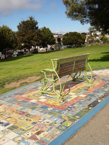
| Mosaic and bench on Precita Park.
| |
| 37.747412, -122.411642
| |
| Two images of murals on Leonard Flynn Elementary School, painted by Precita Eyes Muralists.
| |
| 37.747276, -122.410923
| |
| Playground at Precita Park's east end.
| |
| 37.747038, -122.410902
| |
| Six images of Butterfly Garden along edge of Precita Park playground.
| |
| 37.746911, -122.410741
| |
| 37.746911, -122.410548
| |
| 37.746419, -122.410483
| |
| 37.746413, -122.410076
| |
| Public art in front of private residence on Mullen Street.
| |
| 37.746487, -122.409132
| |
| View southeast across intersection at open bluff above Peralta and Mullen.
| |
| 37.746037, -122.409067
| |
| End of Peralta cul-de-sac, and beginning of several blocks of paths and stairways going up the hill.
| |
| 37.745859, -122.409035
| |
| 37.745689, -122.409014
| |
| 37.745223, -122.408981
| |
| 37.744994, -122.408895
| |
| Three images of ascending the Peralta Stairs.
| |
| 37.744765, -122.408788
| |
| 37.74468, -122.408702
| |
| Two images back to north down the Peralta Stairs.
| |
| 37.744553, -122.408788
| |
| Path from stairs to Peralta Street.
| |
| 37.744247, -122.408767
| |
| 37.743424, -122.40867
| |
| 37.743407, -122.408348
| |
| 37.7433, -122.408456
| |
| Top of Joy Stairs on Franconia, view southeast.
| |
| 37.743266, -122.40822
| |
| 37.743045, -122.408102
| |
| 37.743314, -122.408702
| |
| 37.743255, -122.409217
| |
| 37.743034, -122.409335
| |
| 37.742932, -122.409486
| |
| 37.742949, -122.409947
| |
| 37.742779, -122.40999
| |
| 37.742847, -122.410794
| |
| 37.742856, -122.411503
| |
| 37.742915, -122.412447
| |
| 37.743034, -122.413273
| |
| 37.743331, -122.414206
| |
| Ten images to the east, northeast, north, northwest and west from the northern path at top of Bernal Heights.
| |
| 37.743484, -122.414904
| |
| 37.743054, -122.415258
| |
| 37.742941, -122.415955
| |
| Seven views to the southeast, south, southwest, west, from western end of summit. Last shot looks down over Bernal Hts. Blvd. towards the north.
| |
| 37.742788, -122.41617
| |
| 37.742635, -122.41617
| |
| 37.742457, -122.416105
| |
| 37.74222, -122.415869
| |
| 37.74205, -122.416288
| |
| 37.742118, -122.416888
| |
| 37.742415, -122.417125
| |
| 37.743017, -122.416931
| |
| Two shots northward from the top of Esmeralda Steps.
| |
| 37.743068, -122.417092
| |
| 37.743059, -122.417253
| |
| 37.743272, -122.417275
| |
| 37.743246, -122.417425
| |
| 37.743339, -122.417607
| |
| Six images descending Esmeralda Steps to intersection of Esmeralda and Elsie.
| |
| 37.743518, -122.418058
| |
| Three images going down to top of slides.
| |
| 37.743628, -122.418315
| |
| 37.743747, -122.418616
| |
| 37.743908, -122.419056
| |
| 37.74401, -122.419313
| |
| 37.744086, -122.41956
| |
| Five images descending stairs and street to Coleridge.
| |
| 37.74272, -122.420397
| |
| 37.741346, -122.421266
| |
| Kingston stairs west from Coleridge.
| |
| 37.741744, -122.42236
| |
| 37.741702, -122.42339
| |
| 37.741235, -122.423959
| |
| 37.741015, -122.424324
| |
| 37.739954, -122.424377
| |
| 37.739742, -122.424667
| |
| 37.73908, -122.424967
| |
| 37.738902, -122.425965
| |
| View easterly of Bernal Heights, two images.
| |
| 37.738851, -122.42751
| |
| 37.738792, -122.4281
| |
| The Bell Mansion, built in the 1850s by banker Thomas Bell, friend to Mary Ellen "Mammie" Pleasant.
| |
| 37.739259, -122.428626
| |
| 37.739759, -122.42943
| |
| 37.740135, -122.430117
| |
| Whimsical and inspiring architecture on Laidley Street.
| |
| 37.74037, -122.430482
| |
| 37.740313, -122.430761
| |
| Foot of Harry Stairs.
| |
| 37.740209, -122.430943
| |
| 37.740115, -122.431093
| |
| 37.740056, -122.431233
| |
| 37.73998, -122.431362
| |
| 37.73992, -122.431469
| |
| 37.739835, -122.431608
| |
| 37.739776, -122.431694
| |
| Nineteen images of walking up Harry Stairs and views to the east and northeast of the City.
| |
| 37.740107, -122.431962
| |
| 37.740472, -122.432306
| |
| 37.740862, -122.432735
| |
| view from Beacon Street of Billy Goat Hill
| |
| 37.741057, -122.43311
| |
| 37.741235, -122.433261
| |
| 37.741431, -122.433132
| |
| Thirteen images of spectacular views from here, and some of kids swinging on big rope swing that used to hang from tree.
| |
| 37.741566, -122.433282
| |
| 37.741592, -122.433497
| |
| 37.741668, -122.433711
| |
| 37.741889, -122.433282
| |
| 37.74222, -122.433368
| |
| View south of Billy Goat Hill, remnant of old Gray Bros. Quarry.
| |
| 37.742584, -122.433389
| |
| 37.743715, -122.433443
| |
| 37.744691, -122.433529
| |
| Foot of Castro Street stairs, view south towards Billy Goat Hill
| |
| 37.745115, -122.433604
| |
| 37.745531, -122.433636
| |
| 37.745868, -122.433625
| |
| Views of open space hilltop at Duncan and Castro.
| |
| 37.746088, -122.433454
| |
| 37.746173, -122.433733
| |
| Metal sculptures on slope above dirt road Castro Street.
| |
| 37.746343, -122.43355
| |
| 37.746428, -122.433647
| |
| Wooden Stairs connect Castro Street to these houses.
| |
| 37.746894, -122.433733
| |
| 37.747174, -122.433765
| |
| 37.747361, -122.433636
| |
| Beautiful gardens along Castro between 27th, Newburg, and Cesar Chavez.
| |
| </googlemap>
| |
|
| |
|
|
| |
|
Latest revision as of 13:19, 18 December 2024
Walking Tour
by Chris Carlsson
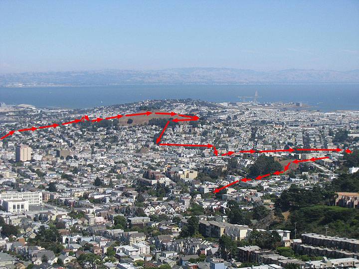
The approximate route of the walking tour is shown in arrows on this image.
Photo: Chris Carlsson
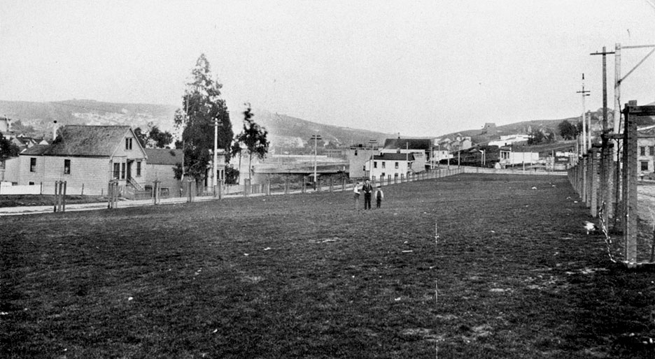
The Board of Supervisors established Precita Park in 1894 at the foot of the north slope of Bernal Heights. One supervisor fought for it because other districts had plentiful and spacious "pleasure grounds," and the south end of the city had almost nothing. It was an early example of the neighborhood fighting to keep open space and to preserve rural character. The view east from the Folsom Street in 1896 of what was Precita Place shows the tree stakes for the original planting of Blackwood acacias. It was dedicated as Bernal Park, and the name was not officially changed until 1973.
Photo/caption: Bernal Heights History Project
Photos: Chris Carlsson
This is a fantastic view-rich walk on July 9, 2005 from Precita Park, up Peralta Stairs, down Joy Stairs, over the summit of Bernal Heights, down the Esmeralda Stairs, down the Kingston Stairs, then popping out on Laidley Street, down Laidley past some great architecture to the Harry Steps, up them to Beacon Street, on to Billy Goat Hill for views and kids swinging on the big Eucalpytus, then up Castro street and Stairs to the summit at Duncan where there's a bit of open space, down the hill and stairs to gardens at Castro and Newburg and 27th Streets. Photos by Chris Carlsson.
Prev. Document Next Document


