Mills Field: Difference between revisions
added contemporary photo of SFO |
added photo |
||
| (7 intermediate revisions by the same user not shown) | |||
| Line 7: | Line 7: | ||
''Photo: San Mateo County History Museum '' | ''Photo: San Mateo County History Museum '' | ||
[[Image: | [[Image:Elizabeth-Mills-Reid,-Whitelaw-Reid,-D-O-Mills,-Elihu-Root,-JP-Morgan,-Ogden-Mills-in-Millbrae.jpg]] | ||
''' | '''Gilded Era plutocrats: (l to r) Elizabeth Mills Reid, Whitelaw Reid (editor, ''New York Tribune''), Darius Ogden Mills, Elihu Root (Secretary of State for President Theodore Roosevelt, Secretary of War for Roosevelt and William McKinley), J.P. Morgan (banker), and Ogden Mills, at the Mills estate in Millbrae, long before air travel, c. 1900.''' | ||
''Photo: | ''Photo: provenance unknown'' | ||
[[Image:Waterfront property east of the Bayshore Highway before airport improvements 1927 pub 2011.032.0021 1.jpg]] | |||
'''Waterfront property east of the Bayshore Highway before airport improvements, 1927.''' | |||
''Photo: courtesy San Francisco Airport Museums'' | |||
[[Image:Mills-Field-airport.jpg]] | |||
'''Mills Field, before it was renamed San Francisco International Airport, c. 1930s''' | |||
''Photo: Shaping San Francisco'' | |||
[[Image:1927 SF airport.jpg]] | |||
'''Mills Field, 1927.''' | |||
''Photo: Shaping San Francisco'' | |||
[[Image:By-1937,-more-than-790,000-square-feet-of-concrete-runways,-taxiways,-and-aircraft-parking-were-in-place,-illuminated-by-modern,-multicolored-lighting-and-45,700-feet-of-underground-power-lines.jpg]] | |||
'''By-1937, almost 800,000 square feet of concrete runways, taxiways, and aircraft parking were in place, illuminated by modern, multicolored lighting and extensive underground power lines.''' | |||
''Photo: SFO Museum'' | |||
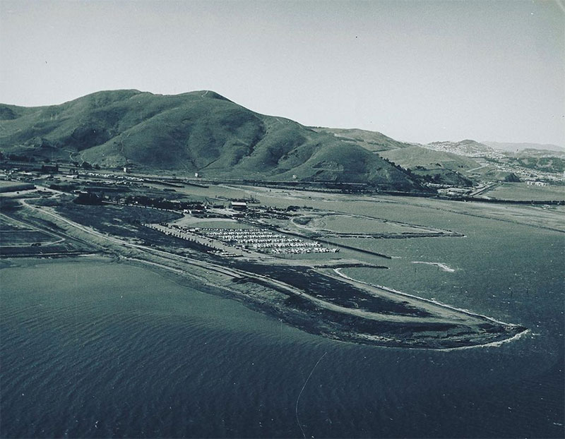
[[Image:Oyster-point-undated-probably-early-1970s ssfhistory.jpg]] | |||
'''Oyster Point between Mills Field/[[San Francisco Airport|SFO]] and [[San Bruno Mountain|San Bruno Mountain]], c. 1970s.''' | |||
''Photo: South San Francisco Historical Association'' | |||
[[San Francisco Airport |Prev. Document]] [[Sunol and Crystal Springs |Next Document]] | [[San Francisco Airport |Prev. Document]] [[Sunol and Crystal Springs |Next Document]] | ||
[[category:San Francisco outside the city]] [[category:1920s]] [[category:Transit]] | [[category:San Francisco outside the city]] [[category:1920s]] [[category:1930s]] [[category:1970s]] [[category:Transit]] [[category:Power and Money]] [[category:1900s]] [[category:South Bay and Peninsula]] | ||
Latest revision as of 22:37, 20 May 2024
Unfinished History
Mills Field in 1927, which eventually grew into San Francisco International Airport. Originally part of the D.O. Mills estate, which in turn was later subdivided into the town of Millbrae and the airport.
Photo: San Mateo County History Museum
Gilded Era plutocrats: (l to r) Elizabeth Mills Reid, Whitelaw Reid (editor, New York Tribune), Darius Ogden Mills, Elihu Root (Secretary of State for President Theodore Roosevelt, Secretary of War for Roosevelt and William McKinley), J.P. Morgan (banker), and Ogden Mills, at the Mills estate in Millbrae, long before air travel, c. 1900.
Photo: provenance unknown
Waterfront property east of the Bayshore Highway before airport improvements, 1927.
Photo: courtesy San Francisco Airport Museums
Mills Field, before it was renamed San Francisco International Airport, c. 1930s
Photo: Shaping San Francisco
Mills Field, 1927.
Photo: Shaping San Francisco
By-1937, almost 800,000 square feet of concrete runways, taxiways, and aircraft parking were in place, illuminated by modern, multicolored lighting and extensive underground power lines.
Photo: SFO Museum
Oyster Point between Mills Field/SFO and San Bruno Mountain, c. 1970s.
Photo: South San Francisco Historical Association


