Market Street Hub Neighborhood: Difference between revisions
Created page with ''''<font face = Papyrus> <font color = maroon> <font size = 4>Historical Essay</font></font> </font>''' ''by John Horn'' 720px|thumb '''Valencia ...' |
added lost landscapes video |
||
| (18 intermediate revisions by 2 users not shown) | |||
| Line 6: | Line 6: | ||
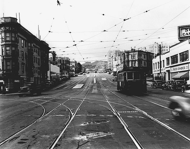
'''Valencia and Market, 1945, when the intersection was still the heart of a now-forgotten neighborhood called "The Hub."''' | '''Valencia and Market, 1945, when the intersection was still the heart of a now-forgotten neighborhood called "The Hub."''' | ||
[[Image:Market-west-at-Valencia-Sept-14-1945-SFDPW.jpg|720px]] | |||
'''Market at Valencia (tracks turn left onto Valencia), Sept. 14, 1945.''' | |||
''Photo: SFDPW, courtesy C.R.collection'' | |||
[[Image:Hub 40s.jpg]] | [[Image:Hub 40s.jpg]] | ||
| Line 11: | Line 17: | ||
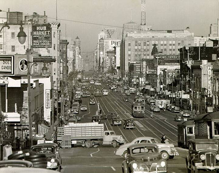
'''The Hub, looking east on Market from apx. Octavia, 1940s.''' | '''The Hub, looking east on Market from apx. Octavia, 1940s.''' | ||
[[Image:Market 1883.jpg| | [[Image:Market-sw-from-Van-Ness-c-1932 72dpi.jpg|720px]] | ||
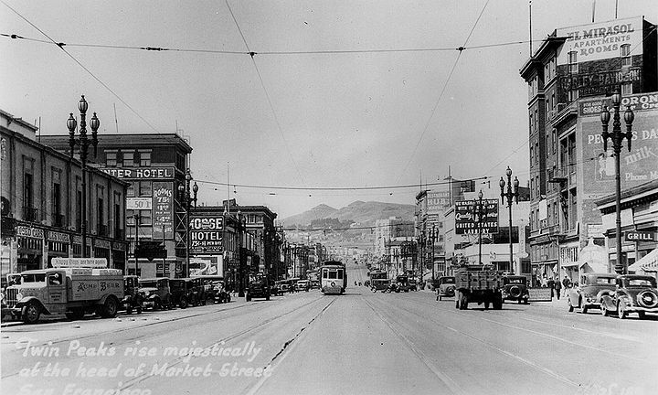
'''Market Street west from Van Ness, c. 1932, into the heart of the Hub neighborhood.''' | |||
''Photo: C.R.collection'' | |||
<iframe src="https://archive.org/embed/market-street-12th-to-6th-c-1940s-llsf-2016-20-mbps-1" width="640" height="480" frameborder="0" webkitallowfullscreen="true" mozallowfullscreen="true" allowfullscreen></iframe> | |||
'''A trip down Market Street in the 1940s from approximately 12th Street in the Hub, driving east across Van Ness, past 11th Street and 10th Street where the Merchandise Mart Building (later Twitter) is visible on the left, and the Fox Theater on the right. Eventually it proceeds as far as 6th Street, turns south and drives as far as Mission Street.''' | |||
''Video: from "Lost Landscapes 11, 2016" by Rick Prelinger, courtesy Prelinger Archives'' | |||
[[Image:Market 1883.jpg|720px]] | |||
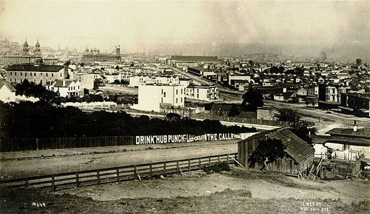
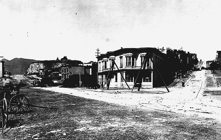
'''Looking east on Buchanan towards Market, c. 1883.''' | '''Looking east on Buchanan towards Market, c. 1883.''' | ||
[[Image:Hermann-St-east-fr-Buchanan-towards-Market-and-Laguna-1932-SFPL 72dpi.jpg|720px]] | |||
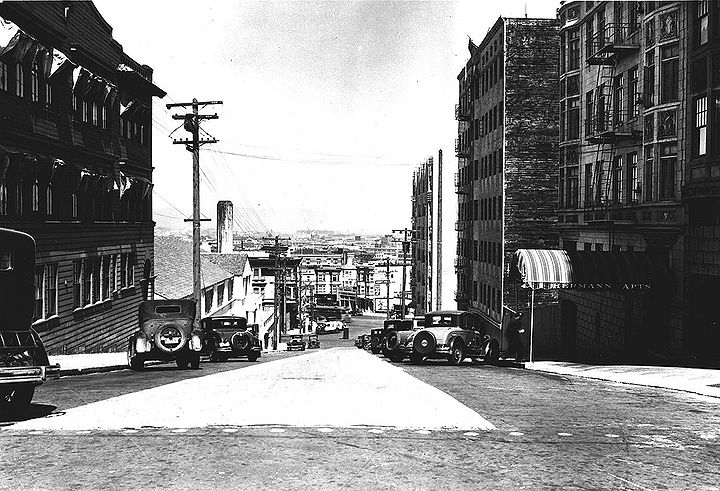
'''Hermann Street east from Buchanan towards Market and Laguna, 1932., San Francisco Teachers College (later San Francisco State College) at left.''' | |||
''Photo: San Francisco History Center, SF Public Library, courtesy C.R. collection'' | |||
[[Image: | [[Image:Market-and-Haight-w-Mint-Hill-and-Twin-Peaks-c-1900-SFPL.jpg|720px]] | ||
''' | '''Market and Haight intersection, c. 1900. Mint Hill still prominent on north side of Market at top of hill.''' | ||
''Photo: San Francisco History Center, SF Public Library, courtesy C.R. collection'' | |||
[[Image:Market-Street-and-Haight-Street-Looking-West -June-19-1919 U06568.jpg]] | |||
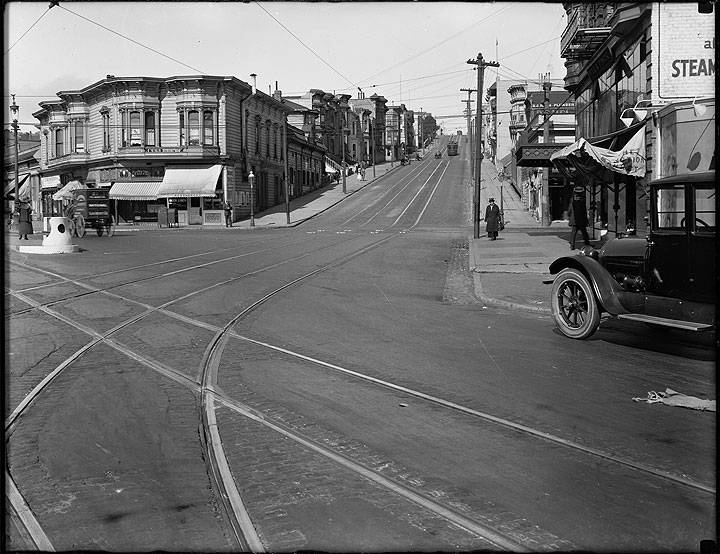
'' | '''Same intersection, June 19, 1919.''' | ||
''Photo: SFMTA, U06568'' | |||
For many decades beginning in the 1880s through the 1950s, the intersection of Market, Valencia, Haight and Gough Streets was popularly known as the “Hub,” because no fewer than four streetcar lines converged there either on their way downtown or outbound to outlying neighborhoods. The Municipal Railway and the Market Street Railway ran on four tracks on Market Street; the 9 Valencia ran on Valencia and the 7 Haight on Haight Street. The intersection was a busy [[MUNI History III: Financial Problems--The Depression, War and Merger|transit hub]], with streetcar lines radiating out from it along Market St., Valencia and Haight Streets. Over the course of decades, the intersection and surrounding neighborhood remained a transit hub even as streets were reconfigured and streetcar lines were replaced with buses. | |||
The name “Hub” eventually came to stand for the surrounding neighborhood as well as the intersection and was well-known to residents of the City. By the 1930s the neighborhood was alive with thriving businesses and a surrounding residential population. Many well-known businesses located here because of the ease of public transportation and the central location, including the Hub pharmacy (for many years San Francisco’s only 24-hour pharmacy), Hub Bowling and the McRoskey Mattress Company. McRoskey is the only business from the Hub area that survives to this day. | The name “Hub” eventually came to stand for the surrounding neighborhood as well as the intersection and was well-known to residents of the City. By the 1930s the neighborhood was alive with thriving businesses and a surrounding residential population. Many well-known businesses located here because of the ease of public transportation and the central location, including the Hub pharmacy (for many years San Francisco’s only 24-hour pharmacy), Hub Bowling and the McRoskey Mattress Company. McRoskey is the only business from the Hub area that survives to this day. | ||
[[Image:Airflex late-20s.jpg]] | |||
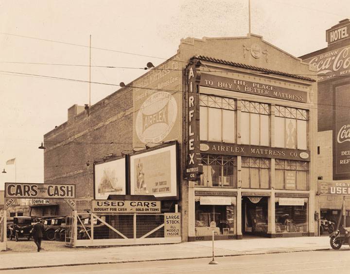
'''McRoskey Mattress Company, 1920s, when Gough Street did not yet go through Market to Mission.''' | '''McRoskey Mattress Company, 1920s, when Gough Street did not yet go through Market to Mission.''' | ||
| Line 54: | Line 76: | ||
''Photo: SFMTA'' | ''Photo: SFMTA'' | ||
[[Image:Work-Crew-Improving-Streetcar-Tracks-at-Market-Street-near-Gough-with-Air-Compressor-and-Overhead-Hose-Line August-6-1930-U12324.jpg]] | |||
'''Work crew improving streetcar tracks on Market Street near Octavia, August 6, 1930.''' | |||
''Photo: SFMTA, U12324'' | |||
[[Image:Improving-Streetcar-Tracks-at-Market-St-near-Gough-with-air-compressor-and-ovehead-hose-line-Aug-6-1930-U12326.jpg]] | |||
'''Another angle of the same work project, August 6, 1930.''' | |||
''Photo: SFMTA, U12326'' | |||
[[Image:Reconstruction-Market-Street-May-1931 72dpi.jpg|720px]] | |||
'''Market Street being rebuilt in May 1931.''' | |||
''Photo: C.R collection'' | |||
The name faded from public memory after the conversion of the Valencia and Haight street lines to bus service and the removal of two streetcar tracks from Market Street with the dissolution of the Market Street Railway, all in the 1940s. The neighborhood went into decline beginning in the late 1940s. | The name faded from public memory after the conversion of the Valencia and Haight street lines to bus service and the removal of two streetcar tracks from Market Street with the dissolution of the Market Street Railway, all in the 1940s. The neighborhood went into decline beginning in the late 1940s. | ||
| Line 68: | Line 108: | ||
''Photo: San Francisco History Center, San Francisco Public Library'' | ''Photo: San Francisco History Center, San Francisco Public Library'' | ||
[[Image:South-Van-Ness-south-from-Mission-and-Otis-Sept-15-1931-SFDPW.jpg|720px]] | |||
'''South Van Ness extension under construction, southerly view from Mission and Otis, Sept. 15, 1931.''' | |||
''Photo: SFDPW, courtesy C.R. collection'' | |||
[[Image:Mission-and-12th-1912 72dpi.jpg|720px]] | |||
'''Mission and 12th Street, 1912.''' | |||
''Photo: C.R. collection'' | |||
Today the reference to the “Hub” is largely forgotten except to history buffs, but a movement to revive the name in reference to a larger area with the intersection as its nexus has begun as the neighborhood becomes a part of the revival of the area in general and a reconfiguration of the intersection under the Market and Octavia Plan. Several landmark structures populate the neighborhood today as it is poised for revival. | Today the reference to the “Hub” is largely forgotten except to history buffs, but a movement to revive the name in reference to a larger area with the intersection as its nexus has begun as the neighborhood becomes a part of the revival of the area in general and a reconfiguration of the intersection under the Market and Octavia Plan. Several landmark structures populate the neighborhood today as it is poised for revival. | ||
[[category:Mission]] [[category:Hayes Valley]] [[category:Civic Center]] [[ | [[category:Mission]] [[category:Hayes Valley]] [[category:Civic Center]] [[category:1900s]] [[category:1880s]] [[category:1930s]] [[category:1940s]] [[category:1920s]] [[category:2010s]] [[category:transit]] [[category:roads]] [[category:Music]] | ||
[[category:1960s]] | |||
Latest revision as of 23:27, 2 November 2023
Historical Essay
by John Horn
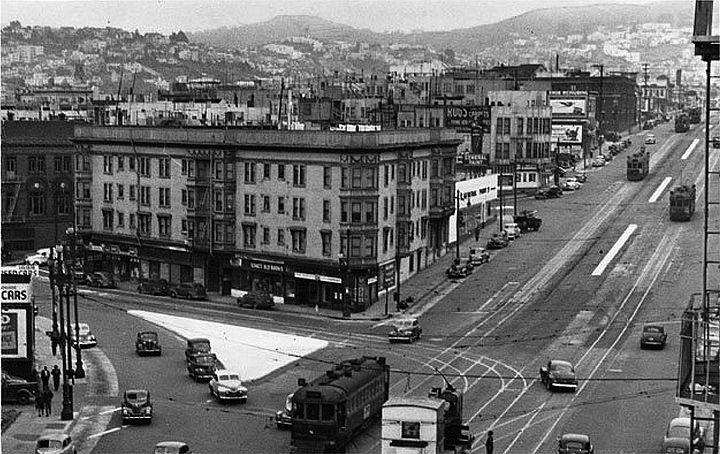
Valencia and Market, 1945, when the intersection was still the heart of a now-forgotten neighborhood called "The Hub."
Market at Valencia (tracks turn left onto Valencia), Sept. 14, 1945.
Photo: SFDPW, courtesy C.R.collection
The Hub, looking east on Market from apx. Octavia, 1940s.
Market Street west from Van Ness, c. 1932, into the heart of the Hub neighborhood.
Photo: C.R.collection
A trip down Market Street in the 1940s from approximately 12th Street in the Hub, driving east across Van Ness, past 11th Street and 10th Street where the Merchandise Mart Building (later Twitter) is visible on the left, and the Fox Theater on the right. Eventually it proceeds as far as 6th Street, turns south and drives as far as Mission Street.
Video: from "Lost Landscapes 11, 2016" by Rick Prelinger, courtesy Prelinger Archives
Looking east on Buchanan towards Market, c. 1883.
Hermann Street east from Buchanan towards Market and Laguna, 1932., San Francisco Teachers College (later San Francisco State College) at left.
Photo: San Francisco History Center, SF Public Library, courtesy C.R. collection
Market and Haight intersection, c. 1900. Mint Hill still prominent on north side of Market at top of hill.
Photo: San Francisco History Center, SF Public Library, courtesy C.R. collection
Same intersection, June 19, 1919.
Photo: SFMTA, U06568
For many decades beginning in the 1880s through the 1950s, the intersection of Market, Valencia, Haight and Gough Streets was popularly known as the “Hub,” because no fewer than four streetcar lines converged there either on their way downtown or outbound to outlying neighborhoods. The Municipal Railway and the Market Street Railway ran on four tracks on Market Street; the 9 Valencia ran on Valencia and the 7 Haight on Haight Street. The intersection was a busy transit hub, with streetcar lines radiating out from it along Market St., Valencia and Haight Streets. Over the course of decades, the intersection and surrounding neighborhood remained a transit hub even as streets were reconfigured and streetcar lines were replaced with buses.
The name “Hub” eventually came to stand for the surrounding neighborhood as well as the intersection and was well-known to residents of the City. By the 1930s the neighborhood was alive with thriving businesses and a surrounding residential population. Many well-known businesses located here because of the ease of public transportation and the central location, including the Hub pharmacy (for many years San Francisco’s only 24-hour pharmacy), Hub Bowling and the McRoskey Mattress Company. McRoskey is the only business from the Hub area that survives to this day.
McRoskey Mattress Company, 1920s, when Gough Street did not yet go through Market to Mission.
Photo: Courtesy McRoskey Mattress Company
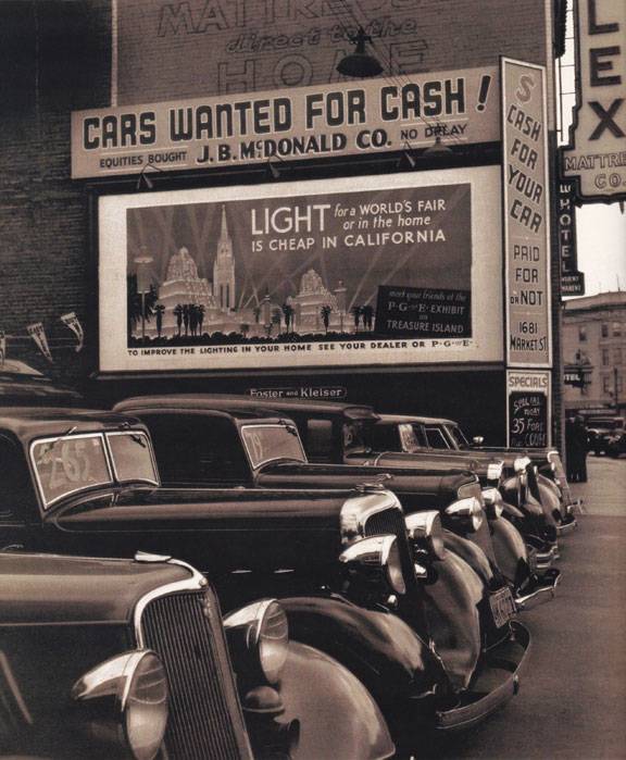
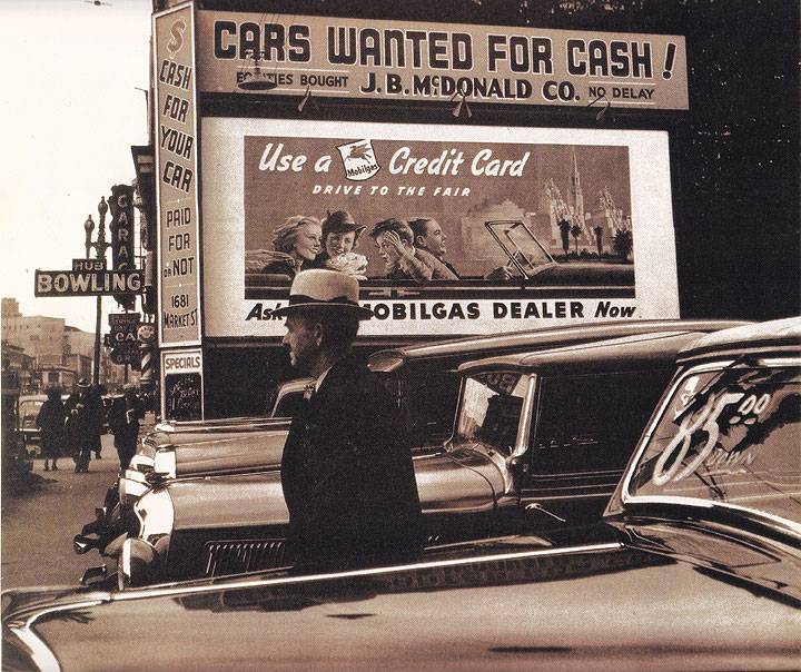
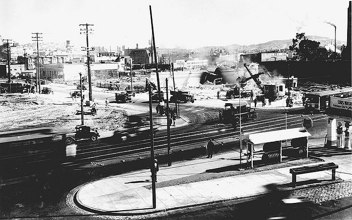
Used car lot on Market in 1939 where Gough now crosses through.
Used car lot on Market Street where Gough now runs to Mission Street,circa 1939. Note the sign in background: Hub Bowling, 1675 Market Street.
Photos: Courtesy McRoskey Mattress Company
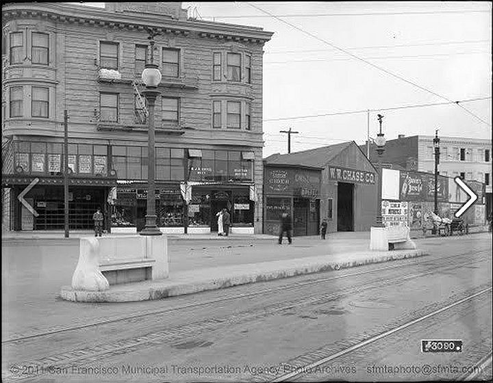
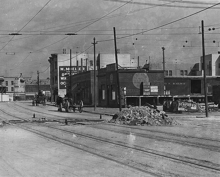
Gough at Market, c. 1907, temporary structures still abound after quake.
Photo: SFMTA
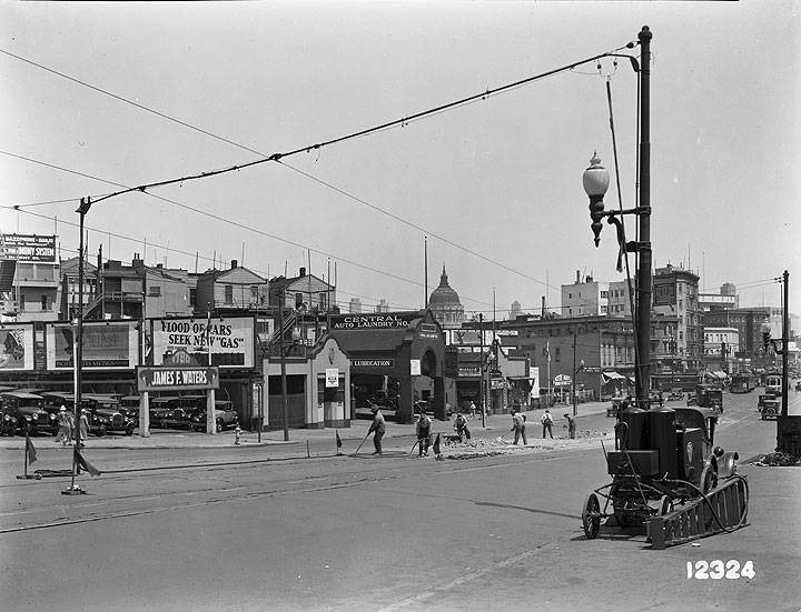
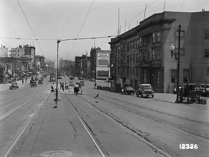
Work crew improving streetcar tracks on Market Street near Octavia, August 6, 1930.
Photo: SFMTA, U12324
Another angle of the same work project, August 6, 1930.
Photo: SFMTA, U12326
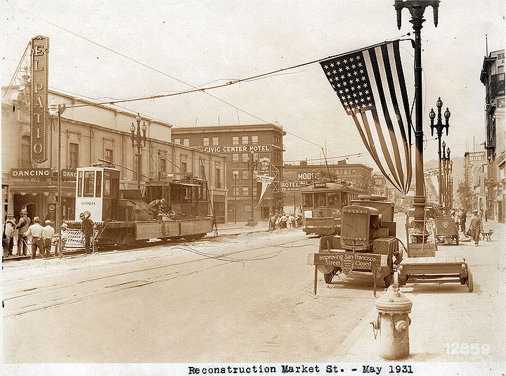
Market Street being rebuilt in May 1931.
Photo: C.R collection
The name faded from public memory after the conversion of the Valencia and Haight street lines to bus service and the removal of two streetcar tracks from Market Street with the dissolution of the Market Street Railway, all in the 1940s. The neighborhood went into decline beginning in the late 1940s.
Building the Gough Street extension, 1949.
Photo: San Francisco History Center, San Francisco Public Library
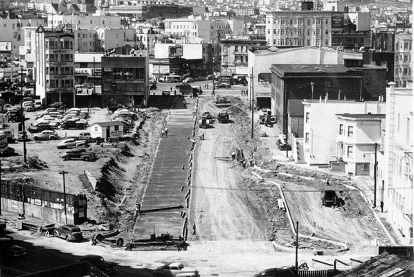
Construction linking Market Street with Mission, South Van Ness Extension, 1930s.
Photo: San Francisco History Center, San Francisco Public Library
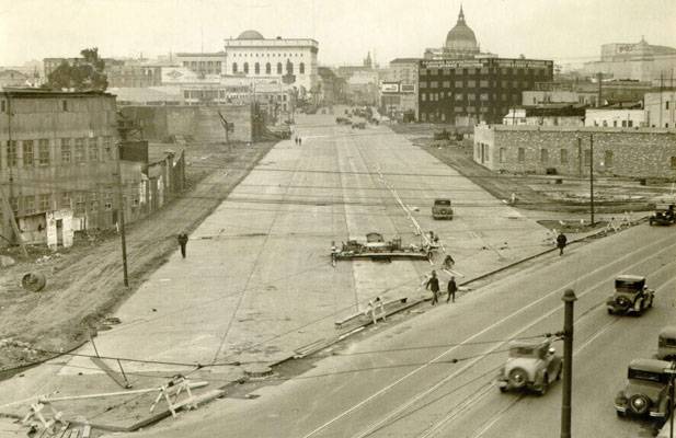
South Van Ness extension under construction, southerly view from Mission and Otis, Sept. 15, 1931.
Photo: SFDPW, courtesy C.R. collection
Mission and 12th Street, 1912.
Photo: C.R. collection
Today the reference to the “Hub” is largely forgotten except to history buffs, but a movement to revive the name in reference to a larger area with the intersection as its nexus has begun as the neighborhood becomes a part of the revival of the area in general and a reconfiguration of the intersection under the Market and Octavia Plan. Several landmark structures populate the neighborhood today as it is poised for revival.

