Mission Plank Road: Difference between revisions
changed next document |
No edit summary |
||
| (6 intermediate revisions by the same user not shown) | |||
| Line 1: | Line 1: | ||
'''<font face = | '''<font face = Papyrus> <font color = maroon> <font size = 4>Primary Source</font></font> </font>''' | ||
<iframe src="https://archive.org/embed/hidden-san-francisco-stop-t-1-mission-plank-road" width="640" height="480" frameborder="0" webkitallowfullscreen="true" mozallowfullscreen="true" allowfullscreen></iframe> | |||
<hr> | |||
[[Image:Foundsf-hsf-icon.gif|link=The Freeway Revolt]]<br> | |||
Next Stop #5: [[The Freeway Revolt|The Freeway Revolt]] | |||
<hr> | |||
[[Image:1852-US-Coast-Survey-map-of-Mission-Bay-w-Mission-Plank-Road.jpg]] | [[Image:1852-US-Coast-Survey-map-of-Mission-Bay-w-Mission-Plank-Road.jpg]] | ||
| Line 5: | Line 14: | ||
'''1852 U.S. Coastal Survey map of San Francisco's Mission Bay and surrounding areas. Mission Plank Road is the long diagonal from upper right, in the developed area near Yerba Buena Cove, to the lower left where Mission Dolores is, crossing a marked swampy wetland at apx. today's 7th Street.''' | '''1852 U.S. Coastal Survey map of San Francisco's Mission Bay and surrounding areas. Mission Plank Road is the long diagonal from upper right, in the developed area near Yerba Buena Cove, to the lower left where Mission Dolores is, crossing a marked swampy wetland at apx. today's 7th Street.''' | ||
“Mission Bay’s slender connection to Gold Rush San Francisco is the Mission Plank Road. (today’s Mission Street), which opened as a toll road in 1851. Its three-and-a-quarter-mile length ran into trouble for the contractors where it crossed the line of Seventh Street (shown but not named on the map). | <blockquote>“Mission Bay’s slender connection to Gold Rush San Francisco is the Mission Plank Road. (today’s Mission Street), which opened as a toll road in 1851. Its three-and-a-quarter-mile length ran into trouble for the contractors where it crossed the line of Seventh Street (shown but not named on the map). | ||
Here they projected a bridge built on pilings, “but that plan had to be abandoned, to the astonishment and dismay of the contractor; the first pile, forty feet long, at the first blow of the pile driver sank out of sight, indicating that there was no bottom within forty feet to support a bridge. One pile having disappeared, the contractor hoisted another immediately over the first and in two blows drove the second down beyond the reach of the hammer… there was no foundation within eighty feet… pilings were abandoned, and cribs of logs were laid upon the turf so as to get a wider base than offered by piles. The bridge made thus always shook when crossed by heavy teams and gradually settled till it was in the middle about five feet below the original level… the cost of the road was ninety-six thousand dollars, about thirty thousand dollars per mile… the plank road company obtained another franchise for a road on Folsom Street… in 1854 a high tide overflowed the [Folsom] road between Fourth and Fifth and floated off the planking.” | Here they projected a bridge built on pilings, “but that plan had to be abandoned, to the astonishment and dismay of the contractor; the first pile, forty feet long, at the first blow of the pile driver sank out of sight, indicating that there was no bottom within forty feet to support a bridge. One pile having disappeared, the contractor hoisted another immediately over the first and in two blows drove the second down beyond the reach of the hammer… there was no foundation within eighty feet… pilings were abandoned, and cribs of logs were laid upon the turf so as to get a wider base than offered by piles. The bridge made thus always shook when crossed by heavy teams and gradually settled till it was in the middle about five feet below the original level… the cost of the road was ninety-six thousand dollars, about thirty thousand dollars per mile… the plank road company obtained another franchise for a road on Folsom Street… in 1854 a high tide overflowed the [Folsom] road between Fourth and Fifth and floated off the planking.” | ||
—J.S. Hittell, ''History of the City of San Francisco and Incidentally of the State of California'' (San Francisco: A.L. Bancroft & Co., 1878) p. 153. Cited in Nancy Olmsted’s ''Vanished Waters: A History of San Francisco’s Mission Bay'' (San Francisco: Mission Creek Conservancy, 1986)</blockquote> | |||
[[Image:1853 pilings.jpg|800px]] | |||
[[Image:1853 closeup on bog and swamps.jpg|800px]] | |||
“J.S. Hittell, writing in 1878, goes on to observe that, although these marshy areas were called swamps, | “J.S. Hittell, writing in 1878, goes on to observe that, although these marshy areas were called swamps, | ||
<blockquote>“They seem to have been for part of their area at least, subterranean lakes from forty to eighty feet deep, covered by a crust of peat moss eight or ten feet thick… When the streets were first made, the weight of the sand pressed the peat down, so that the water stood where the surface was dry before… More than once a contractor had put on enough sand to raise the street to the official grade, and gave notice to the city engineer to inspect the work, but in the lapse of a day between notice and inspection the sand had sunk down six or eight feet… heavy sand crowded under the light peat at the sides of the street and lifted it up eight or ten feet above its original level, in muddy ridges full of hideous cracks…it was also pushed sidewise so that houses and fences built upon it were carried away from their original position and tilted up at singular angles…”</blockquote> | |||
''1856 image: Annals of San Francisco'' | [[Image:Mission-Plank-Road-1856 1625049.jpg]] | ||
''1856 image: Annals of San Francisco, courtesy David Rumsey collection'' | |||
[[Image:9th-and-Mission-07-6629.jpg]] | [[Image:9th-and-Mission-07-6629.jpg]] | ||
| Line 27: | Line 42: | ||
'''Market and Powell, c. 1851 looking from the southeast, approximately near today's 2nd and Folsom. Note the surprisingly steep sand dunes covered in dune scrub on both sides of Market Street.''' | '''Market and Powell, c. 1851 looking from the southeast, approximately near today's 2nd and Folsom. Note the surprisingly steep sand dunes covered in dune scrub on both sides of Market Street.''' | ||
''Photo: | ''Photo: OpenSFHistory / wnp71.0522'' | ||
The toll road to the mission probably would have gone out Market Street, but there was an 80-foot sand hill between Second and Third Streets… In the period 1859 to 1873, the ''steam paddy'' (or giant steam shovel—it was said to do the work of twenty Irish laborers at a single stroke) took south-of-Market sand to fill [[MISSION BAY|Mission Bay]]. | |||
[[Image:Green 1857 Coastal Survey Map 3rd and Mission.jpg|800px]] | |||
'''1857 U.S.G.S. Coastal Survey map, showing the dune blocking Market Street just west of 3rd.''' | |||
''Maps courtesy [http://www.davidrumsey.com David Rumsey collection]'' | |||
| Line 36: | Line 57: | ||
[[MISSION BAY|Prev. Document]] [[Unraveling the Mystery of Lake Dolores|Next Document]] | [[MISSION BAY|Prev. Document]] [[Unraveling the Mystery of Lake Dolores|Next Document]] | ||
[[category:SOMA]] [[category:roads]] [[category:1850s]] [[category:maps]] [[category:2000s]] [[category:water]] [[category:shoreline]] [[category:Mission Bay]] [[category:Irish]] | [[category:SOMA]] [[category:roads]] [[category:1850s]] [[category:maps]] [[category:2000s]] [[category:water]] [[category:shoreline]] [[category:Mission Bay]] [[category:Irish]] [[category:Transit]] | ||
Latest revision as of 13:06, 28 September 2021
Primary Source
![]()
Next Stop #5: The Freeway Revolt
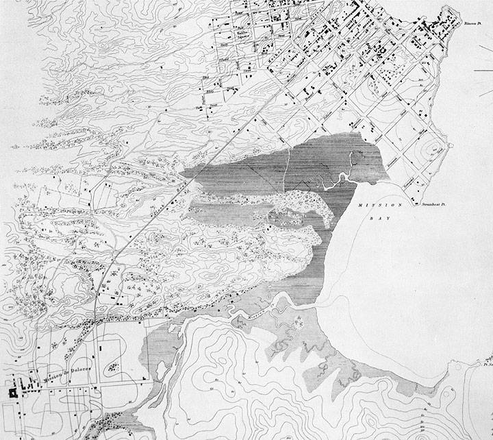
1852 U.S. Coastal Survey map of San Francisco's Mission Bay and surrounding areas. Mission Plank Road is the long diagonal from upper right, in the developed area near Yerba Buena Cove, to the lower left where Mission Dolores is, crossing a marked swampy wetland at apx. today's 7th Street.
“Mission Bay’s slender connection to Gold Rush San Francisco is the Mission Plank Road. (today’s Mission Street), which opened as a toll road in 1851. Its three-and-a-quarter-mile length ran into trouble for the contractors where it crossed the line of Seventh Street (shown but not named on the map).
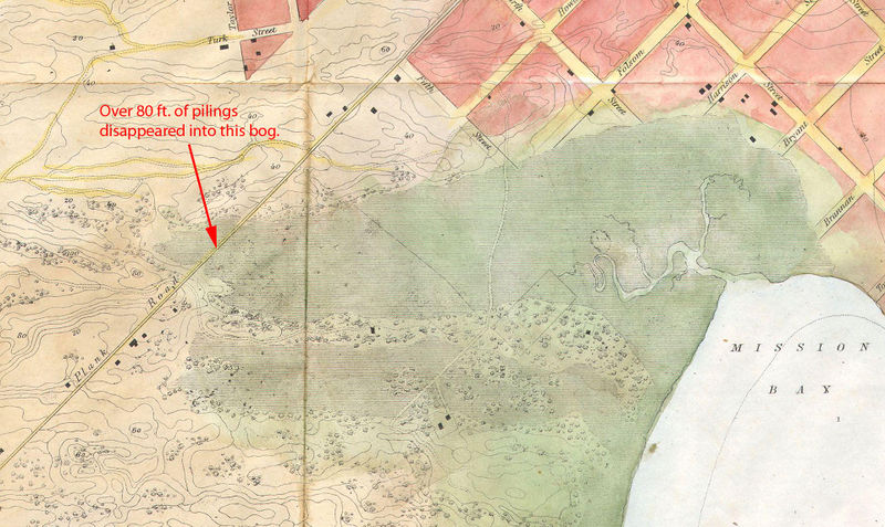
Here they projected a bridge built on pilings, “but that plan had to be abandoned, to the astonishment and dismay of the contractor; the first pile, forty feet long, at the first blow of the pile driver sank out of sight, indicating that there was no bottom within forty feet to support a bridge. One pile having disappeared, the contractor hoisted another immediately over the first and in two blows drove the second down beyond the reach of the hammer… there was no foundation within eighty feet… pilings were abandoned, and cribs of logs were laid upon the turf so as to get a wider base than offered by piles. The bridge made thus always shook when crossed by heavy teams and gradually settled till it was in the middle about five feet below the original level… the cost of the road was ninety-six thousand dollars, about thirty thousand dollars per mile… the plank road company obtained another franchise for a road on Folsom Street… in 1854 a high tide overflowed the [Folsom] road between Fourth and Fifth and floated off the planking.”
—J.S. Hittell, History of the City of San Francisco and Incidentally of the State of California (San Francisco: A.L. Bancroft & Co., 1878) p. 153. Cited in Nancy Olmsted’s Vanished Waters: A History of San Francisco’s Mission Bay (San Francisco: Mission Creek Conservancy, 1986)
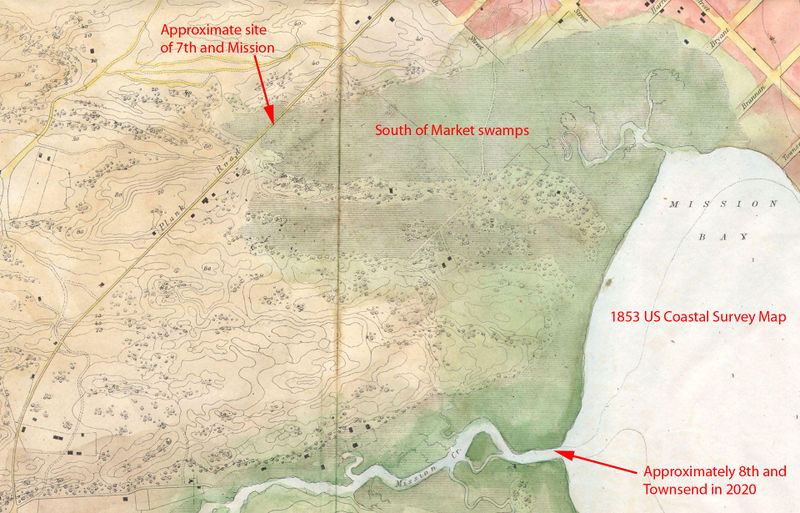
“J.S. Hittell, writing in 1878, goes on to observe that, although these marshy areas were called swamps,
“They seem to have been for part of their area at least, subterranean lakes from forty to eighty feet deep, covered by a crust of peat moss eight or ten feet thick… When the streets were first made, the weight of the sand pressed the peat down, so that the water stood where the surface was dry before… More than once a contractor had put on enough sand to raise the street to the official grade, and gave notice to the city engineer to inspect the work, but in the lapse of a day between notice and inspection the sand had sunk down six or eight feet… heavy sand crowded under the light peat at the sides of the street and lifted it up eight or ten feet above its original level, in muddy ridges full of hideous cracks…it was also pushed sidewise so that houses and fences built upon it were carried away from their original position and tilted up at singular angles…”
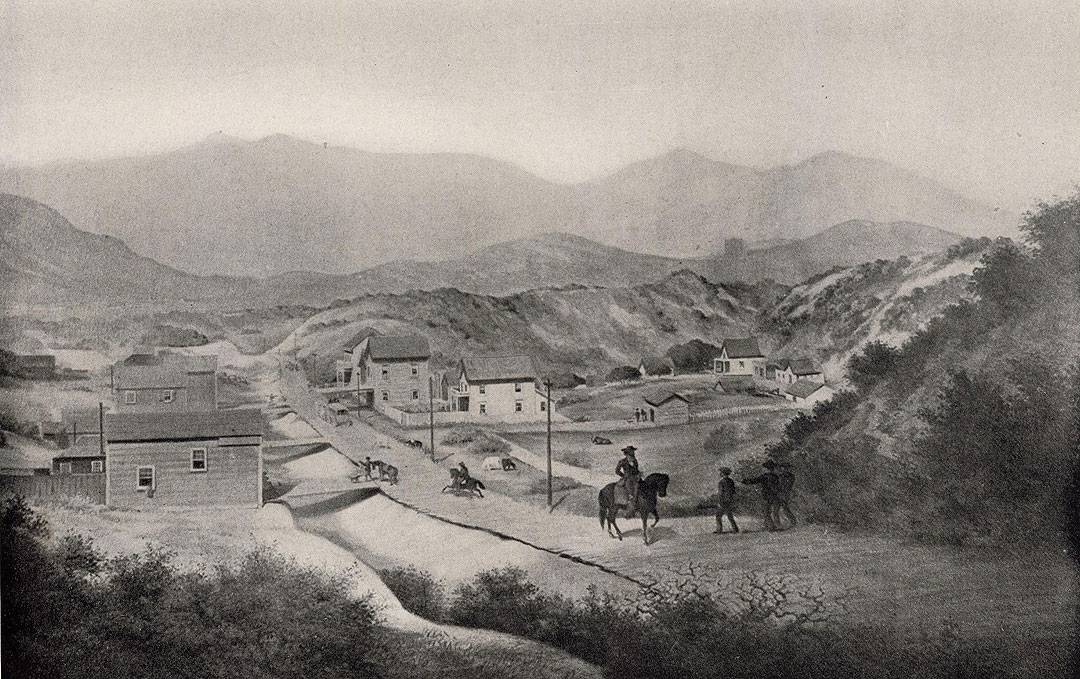
1856 image: Annals of San Francisco, courtesy David Rumsey collection
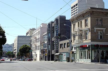
Two views of northwest corner of 9th and Mission, in 1856 and 2007.
2007 photo: Chris Carlsson
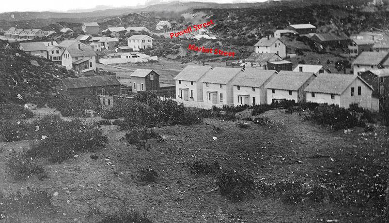
Market and Powell, c. 1851 looking from the southeast, approximately near today's 2nd and Folsom. Note the surprisingly steep sand dunes covered in dune scrub on both sides of Market Street.
Photo: OpenSFHistory / wnp71.0522
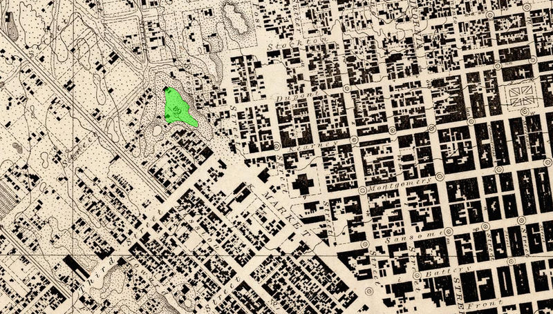
The toll road to the mission probably would have gone out Market Street, but there was an 80-foot sand hill between Second and Third Streets… In the period 1859 to 1873, the steam paddy (or giant steam shovel—it was said to do the work of twenty Irish laborers at a single stroke) took south-of-Market sand to fill Mission Bay.
1857 U.S.G.S. Coastal Survey map, showing the dune blocking Market Street just west of 3rd.
Maps courtesy David Rumsey collection

