Before the I-280 Freeway: Difference between revisions
(added Charles Ruiz photo) |
(changed credit on every picture which all came from CR collection) |
||
| Line 7: | Line 7: | ||
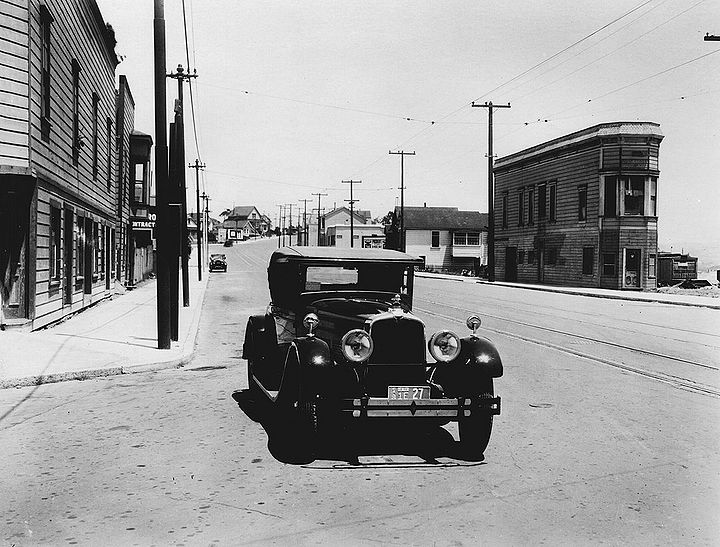
'''San Jose Avenue northwest at Sickles Street, Southern Pacific Railroad running down the street, 1926. Interstate-280 now runs along this right of way.''' | '''San Jose Avenue northwest at Sickles Street, Southern Pacific Railroad running down the street, 1926. Interstate-280 now runs along this right of way.''' | ||
''Photo: | ''Photo: C.R. collection'' | ||
[[Image:Monterey-Blvd-northeast-at-San-Jose-w-Diamond-at-left-and-Holly-Park-in-distant-center--largebldg-is-Junipero-Serra-Grammar-School-June-1953-SFDPT.jpg|720px]] | [[Image:Monterey-Blvd-northeast-at-San-Jose-w-Diamond-at-left-and-Holly-Park-in-distant-center--largebldg-is-Junipero-Serra-Grammar-School-June-1953-SFDPT.jpg|720px]] | ||
| Line 13: | Line 13: | ||
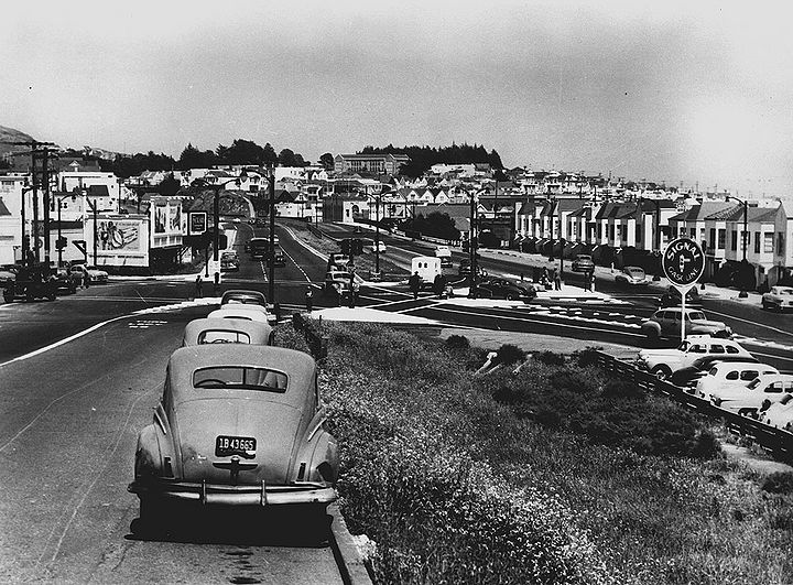
'''Monterey Boulevard northeast at San Jose Avenue. Diamond Street enters at left, and Holly Park is in distance--large building is the former Junipero Serra Grammar School, seen here in June 1953.''' | '''Monterey Boulevard northeast at San Jose Avenue. Diamond Street enters at left, and Holly Park is in distance--large building is the former Junipero Serra Grammar School, seen here in June 1953.''' | ||
''Photo: SFDPT, courtesy | ''Photo: SFDPT, courtesy C.R.collection'' | ||
[[Image:Southwest-San-Francisco-neighborhood-pre-I-280.jpg|720px]] | [[Image:Southwest-San-Francisco-neighborhood-pre-I-280.jpg|720px]] | ||
| Line 19: | Line 19: | ||
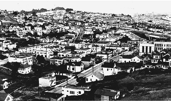
'''Glen Park to southwestern Bernal Heights, c. 1940s.''' | '''Glen Park to southwestern Bernal Heights, c. 1940s.''' | ||
''Photo: | ''Photo: C.R.collection'' | ||
[[Image:Bernal-Ave-(San-Jose-Ave)-sw-at-St-Marys-Ave-SPRR-at-right-1930-SFPL.jpg|720px]] | [[Image:Bernal-Ave-(San-Jose-Ave)-sw-at-St-Marys-Ave-SPRR-at-right-1930-SFPL.jpg|720px]] | ||
| Line 25: | Line 25: | ||
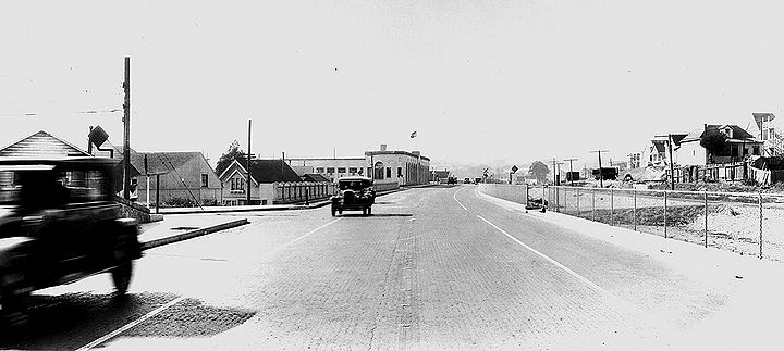
'''Bernal Avenue (now San Jose Avenue) southwest at St. Mary's Avenue with the Southern Pacific railroad at right, at the southern end of the newly widened [[Bernal Cut|Bernal Cut]], seen here in 1930.''' | '''Bernal Avenue (now San Jose Avenue) southwest at St. Mary's Avenue with the Southern Pacific railroad at right, at the southern end of the newly widened [[Bernal Cut|Bernal Cut]], seen here in 1930.''' | ||
''Photo: San Francisco History Center, SF Public Library, courtesy | ''Photo: San Francisco History Center, SF Public Library, courtesy C.R. collection'' | ||
[[Image:San-Jose-Ave-southwest-at-St-Marys-Ave-SP-Colma-Line-and-Arlington-St-at-right-Monterey-Blvd-center-distance-opening-day-new-Bernal-Cut-April-16-1930-SFDPW.jpg|720px]] | [[Image:San-Jose-Ave-southwest-at-St-Marys-Ave-SP-Colma-Line-and-Arlington-St-at-right-Monterey-Blvd-center-distance-opening-day-new-Bernal-Cut-April-16-1930-SFDPW.jpg|720px]] | ||
| Line 31: | Line 31: | ||
'''San Jose Avenue southwest at St. Mary's Avenue. Southern Pacific Colma line and Arlington Street at right. Monterey Blvd. in center distance, on opening day of the new Bernal Cut, April 16, 1930.''' | '''San Jose Avenue southwest at St. Mary's Avenue. Southern Pacific Colma line and Arlington Street at right. Monterey Blvd. in center distance, on opening day of the new Bernal Cut, April 16, 1930.''' | ||
''Photo: SFDPW, courtesy | ''Photo: SFDPW, courtesy C.R. collection'' | ||
[[Image:San-Jose-Ave-(Bernal-Ave)-sw-at-Diamond-St-far-right-w-Monterey-Blvd-up-hill-at-center-and-Joost-at-right-Feb-22-1936-SFPL.jpg|720px]] | [[Image:San-Jose-Ave-(Bernal-Ave)-sw-at-Diamond-St-far-right-w-Monterey-Blvd-up-hill-at-center-and-Joost-at-right-Feb-22-1936-SFPL.jpg|720px]] | ||
| Line 43: | Line 43: | ||
'''Mission Street south over Alemany viaduct, 1926.''' | '''Mission Street south over Alemany viaduct, 1926.''' | ||
''Photo: San Francisco History Center, SF Public Library, courtesy | ''Photo: San Francisco History Center, SF Public Library, courtesy C.R. collection'' | ||
[[Image:I-280-under-construction-at-Mission-overpass-c1965.jpg|720px]] | [[Image:I-280-under-construction-at-Mission-overpass-c1965.jpg|720px]] | ||
| Line 49: | Line 49: | ||
'''I-280 freeway under construction at Mission/Alemany viaduct, c. 1965.''' | '''I-280 freeway under construction at Mission/Alemany viaduct, c. 1965.''' | ||
''Photo: | ''Photo: C.R. collection'' | ||
[[category:transit]] [[category:1930s]] [[category:1950s]] [[category:1960s]] [[category:roads]] [[category:Excelsior]] [[category:Glen Park]] | [[category:transit]] [[category:1930s]] [[category:1950s]] [[category:1960s]] [[category:roads]] [[category:Excelsior]] [[category:Glen Park]] | ||
Revision as of 12:58, 30 September 2016
Unfinished History
The Interstate-280 freeway was the last major freeway built in San Francisco, and one of the few to escape the broad opposition that came to be known as the Freeway Revolt. The valley through which the freeway runs for much of its San Francisco course was once the Islais Creek before it was put into culverts and eventually covered with San Jose Avenue and Alemany Boulevard.
San Jose Avenue northwest at Sickles Street, Southern Pacific Railroad running down the street, 1926. Interstate-280 now runs along this right of way.
Photo: C.R. collection
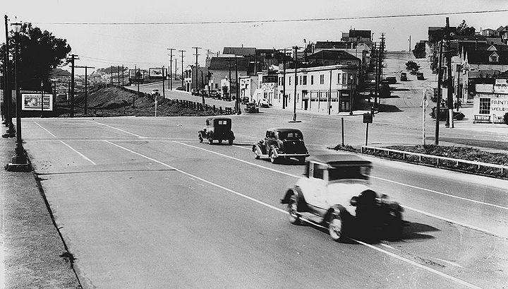
Monterey Boulevard northeast at San Jose Avenue. Diamond Street enters at left, and Holly Park is in distance--large building is the former Junipero Serra Grammar School, seen here in June 1953.
Photo: SFDPT, courtesy C.R.collection
Glen Park to southwestern Bernal Heights, c. 1940s.
Photo: C.R.collection
Bernal Avenue (now San Jose Avenue) southwest at St. Mary's Avenue with the Southern Pacific railroad at right, at the southern end of the newly widened Bernal Cut, seen here in 1930.
Photo: San Francisco History Center, SF Public Library, courtesy C.R. collection
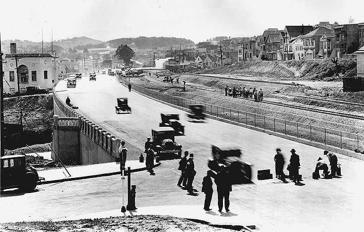
San Jose Avenue southwest at St. Mary's Avenue. Southern Pacific Colma line and Arlington Street at right. Monterey Blvd. in center distance, on opening day of the new Bernal Cut, April 16, 1930.
Photo: SFDPW, courtesy C.R. collection
Bernal Avenue (now San Jose Avenue) southwest at Diamond Street (far right) with Montery Boulevard up hill at left-center, and Joost St. going uphill from right of center, February 22, 1936.
Photo: San Francisco History Center, SF Public Library, courtesy Charles Ruiz collection
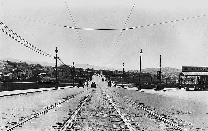
Mission Street south over Alemany viaduct, 1926.
Photo: San Francisco History Center, SF Public Library, courtesy C.R. collection
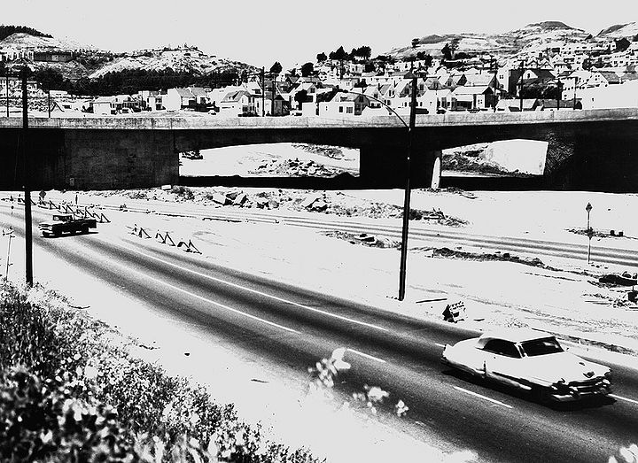
I-280 freeway under construction at Mission/Alemany viaduct, c. 1965.
Photo: C.R. collection

