Liberty Hill from Twin Peaks: Difference between revisions
new page with Cushman photo and current shot matching |
changed credit on 1920s photo which came from C.R. collection |
||
| (4 intermediate revisions by 2 users not shown) | |||
| Line 5: | Line 5: | ||
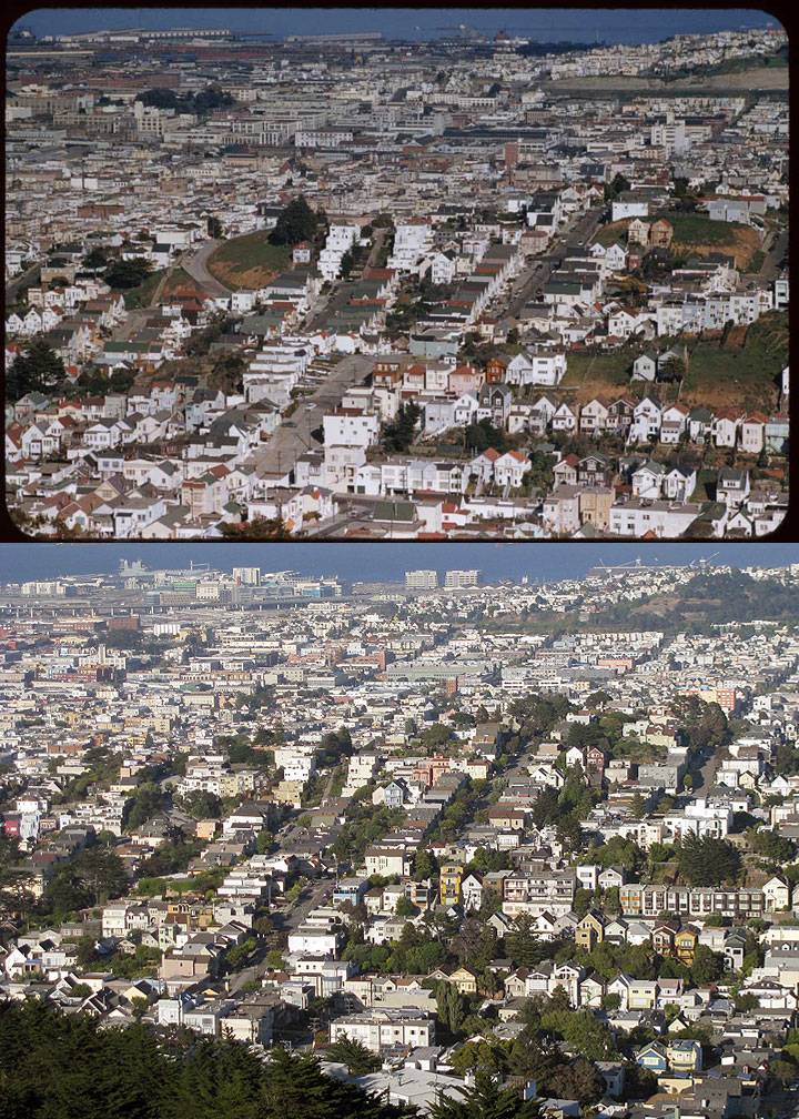
'''Top: March 5, 1955; Bottom: July 6, 2009.''' | '''Top: March 5, 1955; Bottom: July 6, 2009.''' | ||
[http://webapp1.dlib.indiana.edu/cushman/ ''1955 photo: Charles Cushman Collection: Indiana University Archives (P07659)''] | [http://webapp1.dlib.indiana.edu/cushman/ ''1955 photo: Charles Cushman Collection: Indiana University Archives (P07659)''] | ||
''2009 photo: Chris Carlsson'' | |||
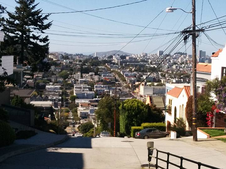
[[category:Noe Valley]] [[category:Eureka Valley]] [[category:hills]] [[category:1950s]] [category:2000s]] | Looking down from Twin Peaks on the west slope of Liberty Hill, curve of 20th Street at left of hill, Liberty Street staircase, then 21st Street and Hill Street heading straight up to the top. Just beyond sight at 21st and Sanchez sits former Mayor "Sunny Jim" Rolph's [[Jim Rolph's Pleasure Den|Pleasure Palace]]. At mid-right of lower photo the higher peak is at 22nd and Collingwood. The next two photos are close 1920s views of Collingwood. | ||
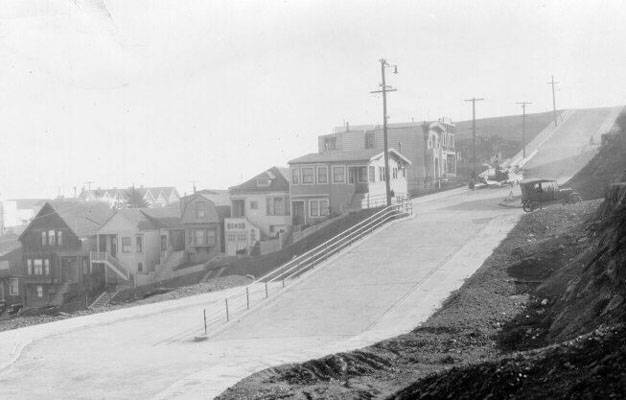
[[Image:Collingwood and 21st c 1920s AAB-3382.jpg]] | |||
'''Collingwood at 21st, going up to 22nd at the top of the street, c. 1920s.''' | |||
''Photo: San Francisco History Center, SF Public Library'' | |||
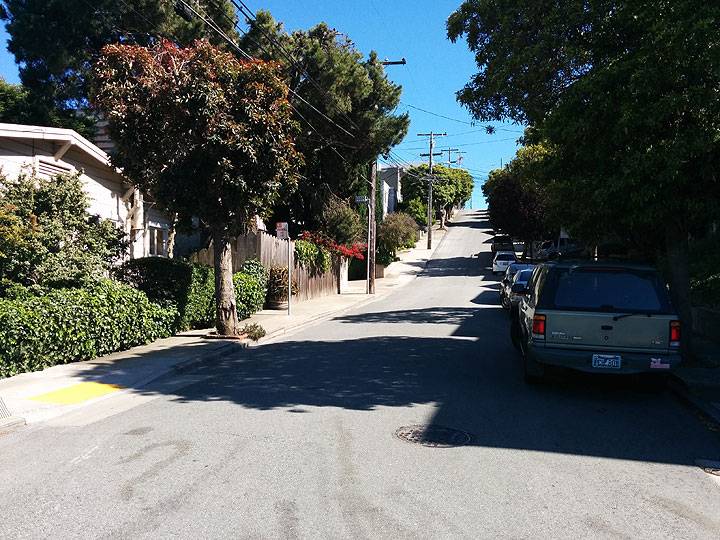
[[Image:South-up-Collingwood 20140613 163712.jpg]] | |||
'''Collingwood at 21st, south up to 22nd, 2014.''' | |||
''Photo: Chris Carlsson'' | |||
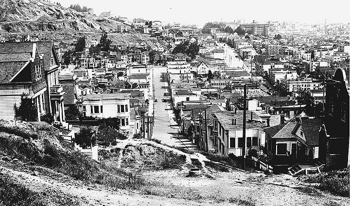
[[Image:Apx-Collingwood-and-21st-c-1920s.jpg|720px]] | |||
'''Collingwood and 21st, looking north towards the eastern edge of [[Corona Heights|Corona Heights]] in the 1920s when it still harbored the [[Gray Brothers Quarry at Corona Heights|Gray Brothers quarry]] there. | |||
''Photo: C. R. collection'' | |||
[[Image:North-down-Collingwood 20140613 163735.jpg]] | |||
'''Looking north down Collingwood from 21st, 2014.''' | |||
''Photo: Chris Carlsson'' | |||
[[1947 view across Noe Valley|Prev. Document]] [[Portola Observation Pt 1937|Next Document]] | |||
[[category:Noe Valley]] [[category:Eureka Valley]] [[category:hills]] [[category:1950s]] [[category:2000s]] [[category:1920s]] [[category:2010s]] | |||
Revision as of 16:35, 20 September 2016
Unfinished History
Top: March 5, 1955; Bottom: July 6, 2009.
1955 photo: Charles Cushman Collection: Indiana University Archives (P07659)
2009 photo: Chris Carlsson
Looking down from Twin Peaks on the west slope of Liberty Hill, curve of 20th Street at left of hill, Liberty Street staircase, then 21st Street and Hill Street heading straight up to the top. Just beyond sight at 21st and Sanchez sits former Mayor "Sunny Jim" Rolph's Pleasure Palace. At mid-right of lower photo the higher peak is at 22nd and Collingwood. The next two photos are close 1920s views of Collingwood.
Collingwood at 21st, going up to 22nd at the top of the street, c. 1920s.
Photo: San Francisco History Center, SF Public Library
Collingwood at 21st, south up to 22nd, 2014.
Photo: Chris Carlsson
Collingwood and 21st, looking north towards the eastern edge of Corona Heights in the 1920s when it still harbored the Gray Brothers quarry there.
Photo: C. R. collection
Looking north down Collingwood from 21st, 2014.
Photo: Chris Carlsson

