Early Development Around Mission Bay, 1850-1857: Difference between revisions
(added image) |
(fixed caption on Crimean War celebration, re: Patrick Carroll's suggestion) |
||
| Line 64: | Line 64: | ||
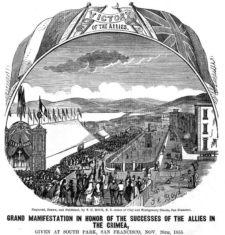
[[Image:1855-celebration-of-success-in-Crimean-War-at-South-Park-A11.19.318n.jpg]] | [[Image:1855-celebration-of-success-in-Crimean-War-at-South-Park-A11.19.318n.jpg]] | ||
'''South Park Party.''' ''A | '''South Park Party.''' ''A tent party ball at South Park to regale dignitaries from France, Britain, The Ottoman Empire (Turkey) and Sardinia (Italy), Nov. 26, 1855. A windmill in the center of the oval irrigated the forlorn yew trees. Only a third of elegant rowhouses were completed as planned. Mission Bay lies in the distance.'' | ||
''Image: San Francisco Maritime National Historical Park (A11.19,318n)'' | ''Image: San Francisco Maritime National Historical Park (A11.19,318n)'' | ||
Revision as of 12:52, 12 December 2014
Historical Essay
by Nancy J. Olmsted
At the time of the Gold Rush, the Mission Dolores was in a sleepy, country setting where Mission Creek meandered through marshes to the broad expanse of Mission Bay. The marshes were the most popular places for duck hunters, who could count on bagging more birds in one hour than they could carry on horseback to the city. Just beyond the mission, a freshwater spring fed a stream lined with willows. This bucolic setting was a great contrast to the muddy, teeming streets and windswept sand hills of the city.
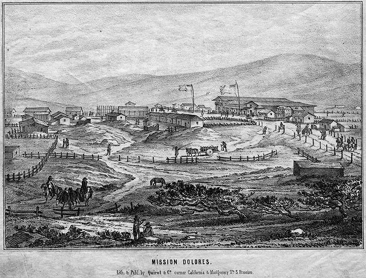
Mission Dolores, 1851. By 1851-52 the “old Mission” had become a goal of many a San Francisco outing at the end of Mission Road. A picturesque remnant of the Spanish past, the dilapidated church had a number of public houses and gambling saloons close by so that culture could be combined with freshment of a lower order.
Image: Bancroft Library (HN001096a)
Two would-be developers, Dr. John Townsend and Cornelius de Boom, envisioned San Francisco’s first suburb on the south bank of Mission Creek. The site was a mile closer to the city and considerably more inviting than a projected Hunters Point development. In 1849 they drew up a grid of streets and offered the land for sale. As there were no families wanting small homes and no road leading to the city, no more was heard of this planned development after 1850. We do not know its precise location beyond “the south bank of Mission Creek.”63 Dr. Townsend and de Boom appear to have had no clear title to the land they hoped to sell, but they must have assumed that empty land should be put to good use.
The beginning of commercial enterprise on Mission Creek was in response to a booming San Francisco market: a brickyard and distillery were the first manufacturing concerns on the creek. Their exact locations are hazy and neither can be located with certainty on the 1852 or the 1857 Coast Survey maps. The bricks were made of clay found on the creek banks and loaded on shallow-draft boats to sail with the tide. Bricks were in great demand in the city as a result of the disastrous fires of the early 1850s, but local builders preferred the superior fired products that arrived from England and the East Coast as ballast on incoming ships. Even less is known about the distillery; in 1878 it was remembered as being at the head of Mission Creek in 1855, from where one could see “the schooners that sailed up and down, loaded with lumber, fuel, bricks, grain and whiskey.”64
It was in 1854, to accommodate to this shipping, that the state legislators designated Mission Creek a navigable stream, and in 1855 they granted a franchise for a bridge across the creek from Brannan Street to Potrero Avenue, with a proviso that the bridge should not obstruct the free navigation of the creek.65
Mission Bay’s isolation from the city is emphasized by an 1853 request made by several factory owners who asked the Board of Aldermen to set aside an area south of Mission Creek for a proposed industrial zone “so remote from the inhabited part of the city that no legal question would likely arise as to what might constitute a nuisance in the district, at least within the period named in the ordinance, until January 1, 1869.” The factory owners ran slaughterhouses and the area they had in mind was near Ninth and Brannan, on the creek. This became the early “Butchers’ Reserve” by city ordinance. The butchers chose this location because the tidal waters from Mission Bay flushed the area twice a day, washing away the waste that was swept through their trap doors. The south-of-Market boys recall supplying patients from the hospital at Sixth and Brannan (French Benevolent Hospital) with “healthy, warm animal blood, at 10 cents a cup, from the slaughterhouses on Mission Creek.”66 The butchers remained on Brannan Street between Sixth and Ninth streets until 1870, when another city ordinance moved them farther south to First and Kentucky; this time they used Islais Creek for their waste disposal. 67
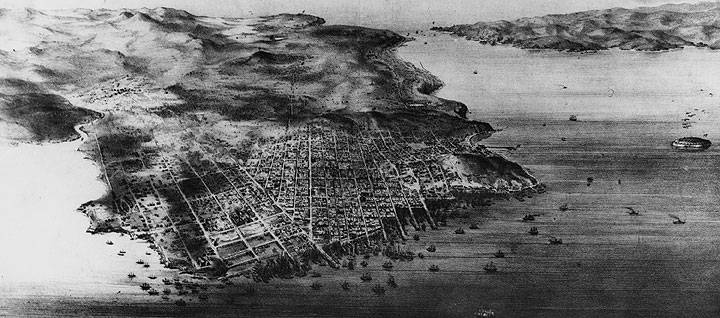
San Francisco From Above. An 1854 birdseye view of San Francisco shows the tidal arm of Mission Creek winding inland from Mission Bay (far left) and the isolated settlement of Mission Dolores beyond. Steamboat Point marks the outer entrance to Mission Bay. The central oval of South Park’s garden has been constructed one block north of Steamboat Point. Development of the city was concentrated north of Market Street, seen here reaching out as a wharf into the bay.
Image: Bancroft Library (brk00012280_24a)
Early Potrero Point Enterprises
Another nuisance-industry ordinance passed by the San Francisco aldermen on May 9, 1853, prohibited the storage of gunpowder within the city limits. As a result, the storeship Dryade, moored at the foot of Telegraph Hill, was removed “two miles from town, where in the winter the wind blows heavily and renders it impossible to load the boat without wetting the powder.”68 On the Coast Survey Map of 1859, the windy, winter anchorage of the Dryade can be found on the southeastern tip of Point San Quentin (Potrero Point) at the Powder Works. Two deepwater wharves extend out to where ships can load their dangerous product. The powder works of the mid-1850s were both isolated and substantial. In two-story brick structures measuring fifty by thirty feet, with walls twelve inches thick, the powder was stored that eventually blasted away many of San Francisco’s famous hills.
Another early Potrero industry can be found on the 1859 Coast Survey Map on Potrero Point, near the powder works. A dark diagonal line labeled “Rope Walk” extends over a marsh and ends at a wharf. This is the 1856 Tubbs Cordage Company that was in the business of importing hemp from Manila and twisting strands into ropes for use in shipping and mines. The Rope Walk was a one-story wooden shed, 35 feet high and 1000 feet long, used by workmen who twisted strands of abaca fibers into ropes as they walked backward along the rope walk. Hardly a nuisance industry, Tubbs Cordage was unusual in its need to cut diagonally through two blocks of land near the waterfront. The southern side of Potrero Point afforded both cheap land and deep-water anchorage that the manufactory required. The company prospered and grew in the 1880s and ‘90s, when they exported rope to South America.
Vegetable Gardens, Race Tracks and Pleasure Gardens
After the first San Francisco survey in 1852, the Coast Survey Map of 1857 demonstrates a major change in the countryside around the Mission Dolores (as it was popularly called). Open lands have become cultivated gardens. Where Folsom and Mission streets turn south (at Eleventh and Twelfth streets today), patterned squares and rectangles abut each other on the map and completely surround the mission with fields of produce raised for a population of 78,000 to the north. Much of the 1852 swampland of Mission Bay had been reclaimed as vegetable gardens in the land between Folsom and Harrison, near Sixth Street.
Near the mission there was fresh water for irrigation and cheap land that was frequently used rather than owned by the produce farmers. There were now two good roads—Mission and Folsom—for wagon delivery to the city’s markets. Windmills can be found on the 1857 map as small symbols shaped like Maltese crosses. From the 1850s through the 1870s the gardens in the Mission Bay district were farmed largely by Chinese, who delivered produce to the city markets and also went from door to door in the better neighborhoods of Rincon Hill and South Park carrying baskets of fresh vegetables swinging from their shoulders. San Francisco’s hotels and restaurants carried on a lively trade and were said to rival Paris and New York in the quality of exotic variety of their menus. Venison and game came from Marin County, butter from Point Reyes, vegetables from Mission Bay gardens and ducks from the marshes, nearby.
During the 1850s the Mission Dolores became a picturesque reminder of an earlier life, the perfect goal for a Sunday outing. Public houses and gambling saloons opened nearby to take care of the trade—“the Grizzly Bear House, the Half-Way House, Milk Punch House, the Nightengale [sic] and the Noantum House,” to name a few from 1854. The course of the Union Race Track can be found just south of the Mission and farther south (beyond this section of the map) was the Pioneer Race Track. The tracks were built here because of a shared conviction that horses ran faster on a wet, springy turf. In 1850, between Twentieth and Twenty-fourth streets, Mr. A.A. Greene built the first regulation track. San Francisco’s racetracks were described as “probably not surpassed by any in the world, where especially on Sunday. . . the most celebrated of the fleet steeds of California are matched against each other to the delight of the multitude.”69 By 1852, horses were being brought in from Australia to race California horses on these fast tracks.
For those whose taste ran more to dancing and dining in a bucolic setting, there was the “Willows”. François Pioche, a French capitalist, built the Willows in a small meadow watered by a stream lined with willow trees (located on the 1859 map between Seventeenth and Nineteenth streets, Valencia and Mission Road). Dances were held in the outdoor pavilion and the willow trees offered pleasant seclusion for outdoor dining. The little resort was very popular with San Franciscans, who could ride out the Mission Plank Road on afternoon excursions and enjoy the warmer weather and the sight of full-grown trees. The Willows sat on land some twenty feet lower than its surroundings, and in 1861 it was flooded, never to reopen. (Bancroft notes that the seasonal freshwater pond described by the mission fathers as the site of their first encampment would have been where the Willows stood in later years.)
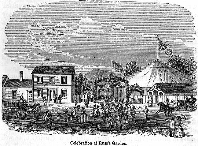
Russ's Garden. Topiary gates twined with flowers and flying flags welcomed a stage from the Omnibus Line, gentlemen on horseback and smart, low-slung landaus, ladies with their parasols, Chinese carrying produce baskets, and couples on foot. Music could be heard from the canvas tent that covered the dance pavilion as groups of gymnasts performed amazing feats for anyone with the small admission price.
Image: Annals of San Francisco, 1855
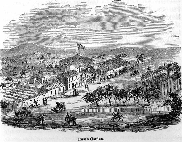
Russ's Garden.
Image: Annals of San Francisco, 1855
Another popular public garden was Russ’s Gardens, seen on the 1859 map at Simmons (Sixth Street) and Folsom. Christian Russ, who made his money in jewelry and real estate speculation during the Gold Rush, opened his family estate to the entire German population of San Francisco on May 1, 1853. An estimated 1,800 Germans “danced, sang, drank, smoked and made merry, as only such an enthusiastic race of mortals could.” 70 Russ proceeded to invite the French to celebrate on Bastille Day, the Irish to drink to St. Patrick and the Yankee population to parade to his gardens on the 4th of July. Russ’s Gardens, for a small fee, was open to all.
In the first years of the Gold Rush people had little time or opportunity for fresh-air outings. The most popular activity was to climb Telegraph Hill and look at the bay, a truly spectacular sight with its “forest of masts,” something never seen before or since. But as life settled down in the mid-1850s and families with children became more common, the need was obvious for “places to take the air” with some trees or gardens. In their hurry to divide city land and sell it to each other, the city fathers had entertained no notion of public spaces. Portsmouth Square was a disgrace, as described by a visiting Englishman, Hinton R. Helper: “. . . it is nothing more or less than a cow-pen, enclosed with unplaned plank. . . In the middle is planted a tall liberty-pole, near which is erected a rude rostrum for lynch-lawyers and noisy politicians. If there is a tree, or a bush, or a shrub, or a sprig of grass, or anything else in or about it that is green. . . nobody has ever seen it; and, as a pleasure ground, it is used only by the four-footed denizens of the city.”71
South Park Party. A tent party ball at South Park to regale dignitaries from France, Britain, The Ottoman Empire (Turkey) and Sardinia (Italy), Nov. 26, 1855. A windmill in the center of the oval irrigated the forlorn yew trees. Only a third of elegant rowhouses were completed as planned. Mission Bay lies in the distance.
Image: San Francisco Maritime National Historical Park (A11.19,318n)
The annalists of San Francisco summed up the state of affairs in 1854: “Over all these square miles of contemplated thoroughfares, there seems no provision made by the projectors for a public park—the true ‘lungs’ of a large city. The existing plaza, or Portsmouth Square, and two or three other diminutive squares delineated on the plan, seem the only breathing-holes intended for the future population of hundreds of thousands. This is a strange mistake, and can only be attributed to the jealous avarice of the city projectors in turning every square vara of the site into an available building lot. Indeed, the eye is wearied, and the imagination quite stupefied in looking over the numberless square—all square—building blocks and mathematically straight lines of streets, miles long, and every one crossing a host of others at right angles. . . . Not only is there no public park or garden but there is not even a circus, oval, open terrace, broad avenue, or any ornamental line of street or building, or verdant space of any kind, other than the three or four small squares alluded to; and which every resident knows are by no means verdant, except in patches where stagnant water collects and ditch weeds grow. ”72
As if in answer to the annalists whose work was published in 1854, South Park was the first planned neighborhood in the city; it was designed in the shape of an oval, around an enclosed garden. Started in 1855 by George Gordon, a British real-estate developer, on what was described as “the only level spot of land free from sand in the city limits,” South Park had a central fenced garden, planted with yew trees that were still of spindly proportions in 1861. Elegant townhouses-narrow, two-story brick buildings with stone facings on their corners-started on the north side of the park but never advanced much beyond a third of the planned oval. The first residents included upper-echelon army and navy officers, social-minded southerners, and well-to-do commission merchants. Gordon had the bad luck to have attempted his planned garden townhouses at the very moment San Francisco had its first financial crisis and real-estate values plummeted. By the time things had recovered, the Second Street cut had devalued Rincon Hill to the north, and finished any social gloss on south of Market real-estate ventures. South Park exists today, although its townhouses are long gone. It runs from Second to Third streets, between Bryant and Brannan. The houses shown in this 1865 woodcut (facing page) are approximately the same as found on the 1859 Coast Survey map.
This is chapter six of "Vanished Waters: A History of San Francisco's Mission Bay" published by the Mission Creek Conservancy, and republished here with their permission.
NOTES
63. Davis, My Sixty Years in California, 315.
64. San Francisco Chronicle, August 18, 1878.
65. California Statutes, 1854, pp. 18-19; 1855, pp. 270-271.
66. South of Market Journal, October, 1923, 24.
67. San Francisco Municipal Reports, 1870-1871, 508.
68. Lamott and Gihon, attorneys’ letters at California Historical Society.
69. Soule et al, The Annals of San Francisco, 663.n
70. Ibid. 664.
71. Charles Lockwood, quoting a letter by Hinton R. Helper in Suddenly San Francisco (San Francisco: San Francisco Examiner, 1978), 126.
72. Soule et al, The Annals of San Francisco, 160-161.
73. North, E.M. “Evolution of Shipping and Shipbuilding in California.” Overland Monthly, February, 1880: 143153.
74. Roger R. and Nancy Olmsted, San Francisco Waterfront (San Francisco: San Francisco Clean Water Program, 1976), 167-168.

